


Area of the second bean harvest 2023-24 reaches new record in Paraná
This week's Agricultural Bulletin also provides information and estimates about the winter harvest in the State
27.03.2024 | 16:44 (UTC -3)
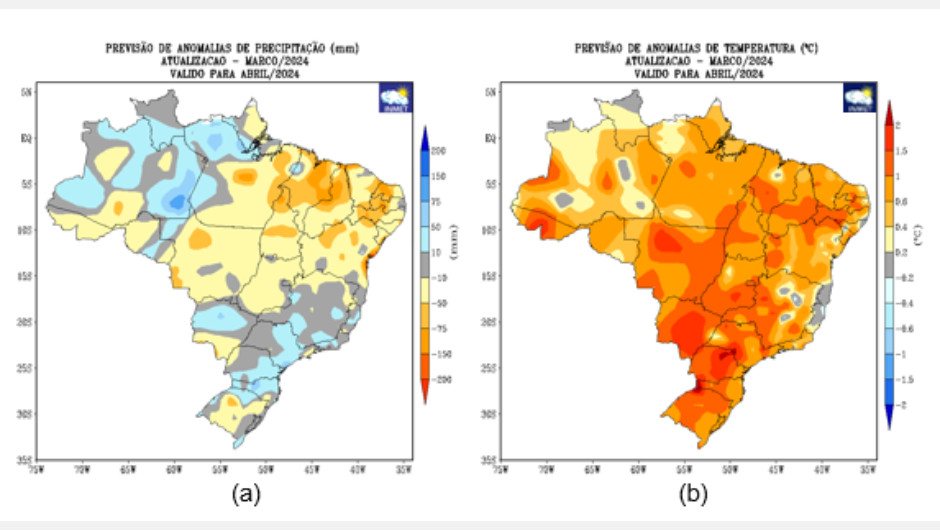
The forecast from the National Institute of Meteorology (Inmet) for the month of April indicates a tendency for rain to be above or close to the average in the western part of the North Region (gray and blue tones on the map in figure 1a). In the center-east of Pará, Tocantins and in a large part of the Northeast Region, the forecast indicates below-average rain (yellow and orange tones on the map in figure 1a). There is also the possibility of rain in the north and east of the Northeast Region due to the action of the Intertropical Convergence Zone (ZCIT), as well as the warming of the Tropical Atlantic.
Considering Inmet's climate forecast for April/2024 and its possible impact on the 2023/2024 grain harvest for different producing regions, it is worth highlighting that Matopiba (a region that encompasses areas of Maranhão, Tocantins, Piauí and Bahia) has been experiencing humidity levels in the soil in recent months, favoring the development of first and second harvest crops. For April/2024, the forecast of below-average rainfall in the region may affect the productive potential of crops under development, however, the harvesting process may benefit. The same scenario is predicted for the states of Mato Grosso and Goiás. April is a month of transition between the rainy and dry seasons in the central part of the country.
In the South and Southeast regions and in the center-north of Mato Grosso do Sul, rainfall volumes close to or above average (gray and blue tones on the map in figure 1a) are predicted for the month of April/2024, maintaining levels of water in the soil and favoring the management and development of first and second harvest crops, but may interrupt the harvest in some areas. However, in the south of Mato Grosso do Sul and part of the center-south of Rio Grande do Sul, there is the possibility of water restrictions in crops, where the forecast indicates rain slightly below average (yellow and orange tones on the map in figure 1a) , which may affect the development of crops that are in phenological stages of greater water need.
The forecast indicates above-average temperatures in practically the entire country, mainly in the western part of the South and Southeast regions, in addition to the Central-West region (indicated on the map in yellow and orange – figure 1b). In the North and Northeast regions, temperatures can exceed 26ºC. In the Southeast Region, they should vary between 22ºC and 26ºC, and in the South Region, between 18ºC and 24ºC. In higher altitude areas of the South and Southeast regions, temperatures below 17ºC are expected.


Receive the latest agriculture news by email