Dry weather is expected to prevail in Rio Grande do Sul for the next few days
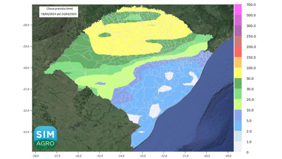
The most significant volumes of rain for the next few days are expected for the North of the State, with values between 20 and 100 mm
19.04.2024 | 13:46 (UTC -3)
Secretariat of Agriculture
The forecast indicates a reduction in temperature with dry and firm weather for the next few days in Rio Grande do Sul. This is what the Integrated Agrometeorological Bulletin 16/2024, from the Secretariat of Agriculture, Livestock, Sustainable Production and Irrigation (Seapi), in partnership with Emater/RS and Irga.
The frontal system that acted in the State on Wednesday (17/4) will move towards the Ocean, resulting in stabilization of high pressure over the State with dry and firm weather throughout Rio Grande do Sul and a reduction in temperatures with the possibility of frost in the highest regions of the Serra. These conditions will persist through Friday (19/4), Saturday (20/4) and Sunday (21/4).
On Monday (22/4), the forecast indicates the action of a frontal system over the State, which will result in volumes of rain in areas of the Western Border, Missions, Middle Plateau and Campanha.
On Tuesday (23/4), this system should advance over the entire state, but maintaining the main accumulations in the northern half.
On Wednesday (24/4), the cold front is expected to move towards the Ocean to the northeast of the State, but may still reflect in accumulations in regions on the border with Santa Catarina.
The most significant volumes of rain for the next few days are expected for the North of the State, with values between 20 and 100 mm. On the Western Border and Campaign, the expected accumulations should be between 5 and 50 mm. On the coast and south of the state, volumes should be lower, reaching up to 10 mm.