Research studies rainfall trends in Mato Grosso over the last 34 years
The rains in Mato Grosso only start consistently from October, the month in which the soybean sowing window opens in the state
06.06.2023 | 14:31 (UTC -3)
Embrapa
Some of the pioneers in the colonization of the mid-north region of Mato Grosso often say that in the past it rained earlier and with greater intensity. A study carried out by Embrapa evaluated rainfall data from the last 34 harvests in search of evidence of a possible change in trends in the state's rainfall regime. The result shows that rainfall anomalies occurred in the period and that the last 17 years were rainier than the previous 17 years.
The work, coordinated by researcher at Embrapa Agrossilvopastoril (MT) Jorge Lulu, analyzed data collected at ten meteorological stations of the National Institute of Meteorology (Inmet) located in different regions of the state, in the period between 1988 and 2022. The information was worked on month by month month in order to calculate the Rain Anomaly Index (IAC). This index varies on a numerical scale, whose number zero represents a period within the normal meteorological scale. Positive values represent periods that are rainier than normal, with a number greater than or equal to four, representing extremely rainy periods. Negative numbers indicate drier periods than expected, and a value equal to or less than -4 represents an extremely dry period.
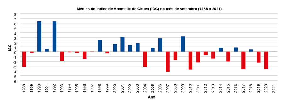
A first result obtained was the confirmation of the characteristic already pointed out by the Agricultural Climate Risk Zoning (Zarc) that, despite rainfall occurring in September, the rains only start consistently from October onwards, this being the opening month of the soybean sowing window in the state. Of the 34 agricultural years analyzed, 19 times the months of September were drier than the expected average, with a negative IAC, and 15 times they were rainier, with a positive IAC. Only on four occasions was the month of September considered very rainy and on two occasions extremely rainy, while in eight years it was considered very dry and in one year it was considered extremely dry.
Figure 1
“This result shows that Zarc is a good guide for producers, as by starting the planting window in October, the risk of losses due to lack of rain is reduced, which are sparse and less frequent in the month of September in the state. ”, explains Jorge Lulu.
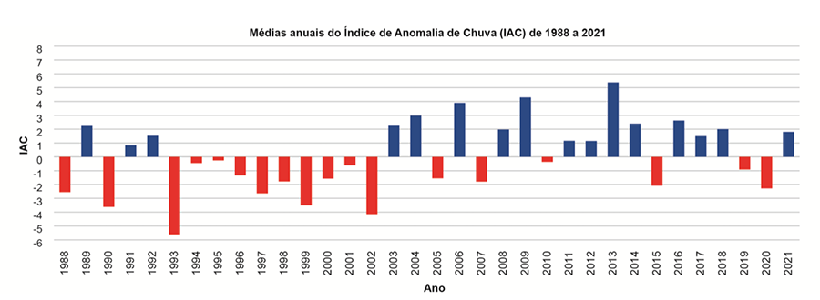
To check whether there is a tendency towards a reduction in the amount of rainfall throughout the agricultural year, the researchers calculated annual averages of the Rainfall Anomaly Indices. The result showed that of the 34 years evaluated, there were 16 years with a positive average IAC and 18 years with a negative average IAC in Mato Grosso, that is, there were more dry years than rainy ones.
However, when dividing the historical series into two halves, one from 1988 to 2004 and the other from 2005 to 2021, it appears that the second half had more rainy years than the first.
The result reflects a behavior observed in all months from October to April, in which the last 17 years were rainier than the previous 17 years. For the driest months, from May to September, the IAC maintained the pattern in all 34 years.
Figure 2
The researcher explains that for a climatological analysis, at least 30 years are needed to identify trends in changes. When considering an interval of 34 years, this work does not indicate that the rains in Mato Grosso are delaying or even consolidating earlier. Confirmation of the occurrence of anomalies, in turn, reinforces the need to follow the planting window recommendations recommended by Zarc.
“It is a way for producers to see not only rain dates, but also observe how deviations from the average may occur over time. With this, the producer can be more alert as anomalies occur and, therefore, it is important to be aware of the zoning windows to reduce risks”, warns Jorge Lulu.
As this research only analyzed precipitation data that occurred, without analyzing climatological phenomena and changes in the landscape, it is not within the scope of the work to understand why anomalies occur each year. Still, it brings advances to knowledge, by confirming that the Rainfall Anomaly Index is a good analysis indicator and that its results are compatible with the precipitation anomaly maps that are generated by the Center for Weather Forecasting and Climate Studies from the National Institute for Space Research (CPTEC/Inpe).
According to the researcher, the work may have future developments with increased information about the water deficit in the historical series. To do this, not only precipitation but also daily temperatures must be taken into account.
Periodic agrometeorological bulletins
Embrapa Agrossilvipastoril publishes three agrometeorological bulletins every year in which it analyzes the behavior of rainfall and soil water balance in different regions of Mato Grosso. The first edition is launched in November, depicting the beginning of the harvest. The second, released in March, shows the period of soybean harvesting and sowing of the second crop in the state. The third edition is launched in June and portrays the occurrence of rains during the second harvest.
These bulletins are used both by the production sector and by the financial and agricultural insurance sectors, being a reference document for understanding the anomalies that occur regionally each agricultural year.