The weekend will see heavy rain in the Southeast Region
The rain will hit Rio de Janeiro, east of São Paulo, center-south of Minas Gerais and Zona da Mata in Minas Gerais
18.01.2024 | 15:35 (UTC -3)
inmet
Next weekend (20 and 21/01), the National Institute of Meteorology (Inmet) warns of an increase in moisture convergence in the middle/lower layer of the atmosphere over the east of the Southeast Region due to the intensification of an area of low pressure, which will give rise to a cold front over the Atlantic Ocean.
This atmospheric pattern, combined with the behavior of winds at high levels and high temperatures in the region, will increase instability, between Saturday (20) and Sunday (21), over the east of São Paulo, south, Zona da Mata and center ( including the capital and Metropolitan Region) of Minas Gerais and Rio de Janeiro.
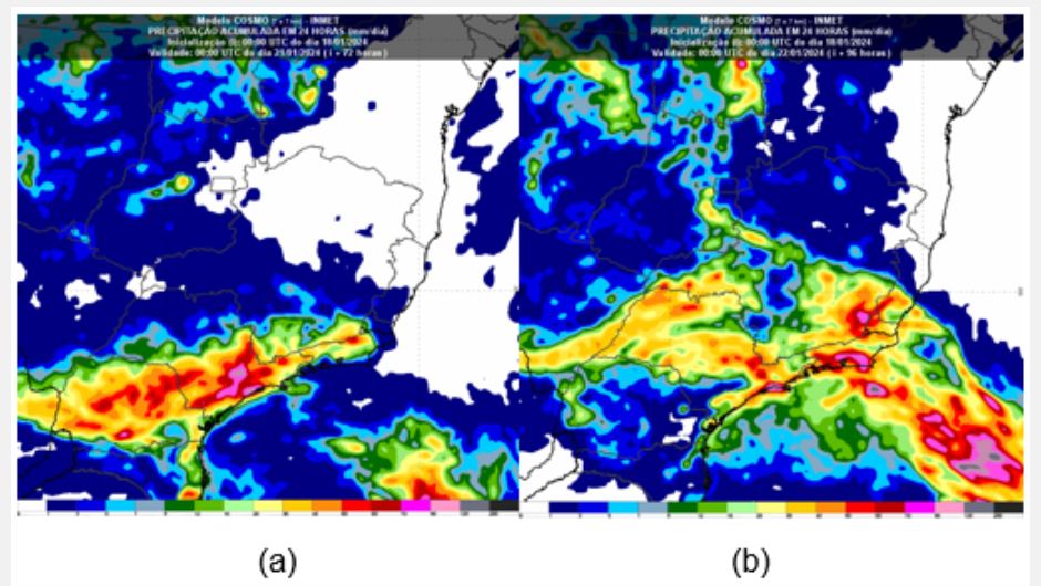
On Saturday, Inmet's forecast indicates that the area most affected by the highest daily rainfall accumulations should be the eastern part of São Paulo (including the capital and Metropolitan Region) and coastal areas, as shown in figure 1a, where some totals of Rainfall can vary between 80 millimeters (mm) and 100 mm in a localized manner. On Sunday, the heaviest rains will occur between the north coast of São Paulo and areas of the south, east (including the capital and Metropolitan Region), the mountains of Rio de Janeiro and the Zona da Mata of Minas Gerais, where it may rain between 70 mm and 90 mm in some points. See figure 1b.
Figure 1: (a) map of the Cosmo 7 km model of accumulated rain forecast in 24 hours – between 21pm (Brasília time) on Friday (19) and 21pm (Brasília time) on Saturday (20) and (b ) map of the Cosmo model 7 km forecast of accumulated rain in 24 hours – between 21pm (Brasília time) on Saturday (20) and 21pm (Brasília time) on Sunday (21)
Subsequently, from Monday (22), intense rains, with significant daily accumulations, should be concentrated between Espírito Santo, southern Bahia, central-northern Minas Gerais, Goiás and the Federal District, a situation that will be monitored with updating numerical weather forecast models in the coming days.