




FMC applies for registration of the herbicide rimisoxafen in Brazil
The active ingredient acts on Groups 12 and 32 and targets resistant weeds in soybeans and corn
28.09.2026 | 17:56 (UTC -3)
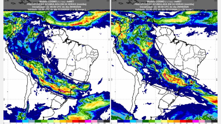
September ends with the formation of a new extratropical cyclone off the coast of Southern Brazil, according to the National Institute of Meteorology (Inmet). The Cosmo numerical weather prediction model indicates that the system should begin to organize between late afternoon and early evening on Tuesday (September 29), between the coast of Uruguay and Rio Grande do Sul.
Throughout Wednesday (September 30th) and Thursday (October 1st), the extratropical cyclone intensifies, occurring when the atmospheric pressure at its center reaches a minimum value of 982 hPa. However, as the extratropical cyclone intensifies, the system also progressively moves away from Brazil.
Even so, the intensification of the cyclone contributes to the advance of a cold front, which will influence weather conditions in parts of the Central-West and Southeast regions and the state of Paraná, with rain, thunderstorms, gusts of wind, and the possibility of hail. On the other hand, the situation begins to change in southern Brazil with the arrival of a cold air mass and a high-pressure system, which should make the weather more stable and cause a drop in temperature in the region.
There is a possibility of frost in some areas of Rio Grande do Sul and Santa Catarina on the first day of October. See the complete forecast by region:
Wednesday (30/9): The weather will be unstable in the western part of the North Region, with showers and thunderstorms expected in Acre, Rondônia, and central and western Amazonas. For these areas, there is a yellow warning for potential storm danger. Isolated showers are expected in the northern, central, and southern Amazonas. Isolated showers are possible in eastern Amazonas, Roraima, and southwestern Pará.
On the other hand, in Tocantins, Amapá, and other areas of Pará, the sky varies from mostly cloudy to partly cloudy, with high temperatures. For southeastern Paraná and central and southern Tocantins, there is a yellow warning of potential danger due to low air humidity. Among the capital cities, the minimum temperature will be 24°C in Rio Branco (AC). In Boa Vista, it is hot from early morning, with a minimum of 28°C and a maximum of 37°C. The maximum temperature among the capital cities will be 39°C in Palmas (TO).
Thursday (October 1st): Rainy weather is expected on the first day of October across much of Amazonas and northern and eastern Rondônia, with thunderstorms. In Acre, isolated showers and thunderstorms are forecast, while isolated rain is possible in eastern Amazonas, central and southern Pará, northern and western Tocantins, and western Roraima.
For Rondônia, Acre, Amazonas, and Roraima, there is a yellow warning indicating potential danger from storms. The sky will be mostly cloudy, but without rain, in Amapá, northern and coastal Pará, and central and southeastern Tocantins. The minimum temperature among the capitals will be 23°C in Rio Branco (AC), and the maximum will be 37°C in Boa Vista (RR) and 39°C in Palmas (TO).
Wednesday (30/9): The weather will be stable across most of the Northeast region. However, isolated showers are expected in the early morning hours in northern Ceará, northern and eastern Rio Grande do Norte, and eastern Paraíba and Pernambuco. The capital cities of Fortaleza (CE), Natal (RN), João Pessoa (PB), and Recife (PE) are within the rainy areas. Cloud cover will decrease by the morning, and no rain is expected in the region during the rest of the day. The sky will be mostly clear across much of the interior. As a result, an orange warning for low humidity is in effect for northern and western Bahia and southeastern Piauí.
For southern Maranhão, southern, eastern and central Piauí, including the capital Teresina (PI), western Pernambuco, and central Bahia, there is a yellow warning of potential danger due to low air humidity. The minimum temperature among the capitals of the Northeast will be 23 °C in Salvador (BA), Maceió (AL) and Recife (PE), and the maximum will be 32 °C in São Luís (MA) and 39 °C in Teresina (PI).
Thursday (October 1st): In much of the region, the weather will be stable, with the sun appearing between clouds. However, there is a possibility of isolated showers in southwestern Maranhão and the eastern parts of Paraíba, Pernambuco, and Alagoas. Sunny weather with few clouds is expected in central and southeastern Piauí, central and western Pernambuco, western Alagoas and Sergipe, and much of Bahia. Temperatures in the capital cities will range from a low of 22°C in Maceió (AL) to a high of 38°C in Teresina (PI).
Wednesday (30/9): The Central-West Region is experiencing two distinct conditions this Wednesday. On the one hand, the western strip of the region, between northwestern and southern Mato Grosso, Mato Grosso do Sul, and southern Goiás, is experiencing unstable weather conditions with rain, while in western and southern Mato Grosso and Mato Grosso do Sul, the rains are accompanied by thunderstorms. These areas are under an orange warning for dangerous storms.
For northwestern and central Mato Grosso, there is a yellow warning for potential storm danger. On the other hand, in central, eastern, and northern Goiás, the Federal District, and eastern Mato Grosso, the day will be sunny, with few clouds and intense heat. There is an orange warning for low air humidity in the Federal District and for central, eastern, and northern Goiás. There is also a yellow warning for potential low air humidity in eastern Mato Grosso and other areas of Goiás.
The minimum temperature among the capitals should not drop below 23°C in Brasília (DF), where the maximum reaches 35°C. In Goiânia, the maximum will be 37°C. It is still quite hot in Cuiabá (MT), but less so than in recent days. The maximum in the capital of Mato Grosso is 38°C, the highest among the capitals of the region.
Thursday (October 1st): October begins with rain in the Central-West region. Areas of instability increase, bringing rain with thunderstorms to the northwest, central, and southeastern parts of Mato Grosso, the central and southern parts of Goiás, and the northeast of Mato Grosso do Sul. There is an orange warning for dangerous storms in southern Mato Grosso, southwestern Goiás, and the northwest, north, and northeast of Mato Grosso do Sul. Isolated showers with thunderstorms affect the Federal District, the remaining areas of Mato Grosso, and the northwest, north, and central parts of Mato Grosso do Sul.
For the northwest, west, and central parts of Mato Grosso, other areas of Mato Grosso do Sul, the Federal District, and the central and southern parts of Goiás, there is a yellow warning of potential danger for storms. No rain is forecast only for the extreme south of Mato Grosso do Sul, in the region of the municipality of Mundo Novo (MS), and for the northeast of Goiás, where the Chapada dos Veadeiros National Park is located.
In Brasília (DF), it will be another day of intense heat, with a minimum of 24 °C and a maximum of 35 °C, the highest among the capitals of the Central-West region. In Cuiabá, the heat continues to weaken, and the maximum temperature will be 32 °C. In Campo Grande, the temperature will be mild, with a maximum of 27 °C.
Wednesday (30 / 9)The last day of September begins with sunshine, few clouds, and intense heat across much of the Southeast Region. However, the formation of an extratropical cyclone and a cold front increases instability early in the day in western and southern São Paulo, along the entire border with Paraná, where rain with thunderstorms is expected. Isolated showers also occur in northern, central, and eastern São Paulo. In the afternoon and evening, the rains continue over São Paulo and move towards the Triângulo Mineiro region, southern Minas Gerais, and Rio de Janeiro, where they occur in isolated areas. There is an orange warning for dangerous storms in São Paulo, the Triângulo Mineiro region, southeastern Minas Gerais, and central, southern, and western Rio de Janeiro.
The weather remains sunny with few clouds in Espírito Santo and in central and northern Minas Gerais. The northwest and north of São Paulo, the Triângulo Mineiro region, and central and southeastern Minas Gerais remain under a red heat wave warning. In the capital cities, temperatures range from a low of 19°C in São Paulo to a high of 35°C in Vitória (ES), 36°C in Rio de Janeiro (RJ), and 37°C in Belo Horizonte (MG).
Thursday (October 1st): The advance of the cold front is causing unstable weather in the Southeast Region. The day will be rainy, with thunderstorms, in the Triângulo Mineiro region, in central, southern and eastern Minas Gerais, in central and southern Espírito Santo, in Rio de Janeiro, and in northwestern, northern, central and eastern São Paulo. For the Triângulo Mineiro region and southern Minas Gerais, for southern and western Rio de Janeiro, and for northwestern, northern and eastern São Paulo, there is an orange warning for dangerous storms. For central Minas Gerais, other areas of Rio de Janeiro and São Paulo, and for southern Espírito Santo, there is a yellow warning for potentially dangerous storms. In areas near Paraná and in northern Espírito Santo, isolated showers are expected.
There is no rain forecast only for the far north of Minas Gerais, bordering Bahia, but the sky will also be very cloudy in this area. In São Paulo, the temperature drops considerably with the arrival of the cold front. The minimum will be 16 °C and the maximum will not exceed 20 °C in the capital of São Paulo. The heat continues in Vitória (ES), with a maximum of 34 °C, and in Belo Horizonte (MG), with a maximum of 35 °C.
Wednesday (30/9): The formation of an extratropical cyclone and the passage of a cold front through the Southern Region will bring rainy weather to the last day of September. Rain with thunderstorms is expected in Paraná, Santa Catarina, and northwestern and northern Rio Grande do Sul. An orange warning for dangerous storms is in effect for Paraná and northern Santa Catarina.
For other parts of Santa Catarina, and for the northwest and north of Rio Grande do Sul, there is a yellow warning of potential danger for storms. Cloudy skies in other areas and a possibility of isolated rain in the central region of Rio Grande do Sul, including the capital Porto Alegre (RS). Temperatures will decrease in the region, with values ranging between a minimum of 16 °C in Porto Alegre (RS) and Florianópolis (SC) and a maximum of 21 °C in Florianópolis (SC) and Curitiba (PR).
Thursday (October 1st): October begins with the arrival of a high-pressure system, which leaves the sky with few clouds in Rio Grande do Sul and stable weather in most of the region. In Santa Catarina, and in western, southwestern, and southern Paraná, the sky will be cloudy, but without rain. There is a possibility of isolated rain only for northwestern, northern, and eastern Paraná, including the capital Curitiba (PR). For northwestern and northern Paraná, there is a yellow warning of potential danger for storms.
The arrival of the cold air mass is causing low temperatures in the mountains of Santa Catarina and southern Rio Grande do Sul, where there is a possibility of frost. Among the capital cities, temperatures are not expected to drop significantly. In Porto Alegre (RS) and Curitiba (PR), a minimum of 13°C. A cold day in Florianópolis (SC), with a maximum of only 16°C. In Curitiba (PR) and Porto Alegre (RS), mild temperatures, with maximums of 22°C and 23°C, respectively.
Receive the latest agriculture news by email



Receive the latest agriculture news by email