



Strong El Niño worries producers in Rio Grande do Sul until September.
Copaaergs bulletin predicts above-average rainfall and provides guidance on crop management to reduce risks.
22.06.2026 | 17:34 (UTC -3)
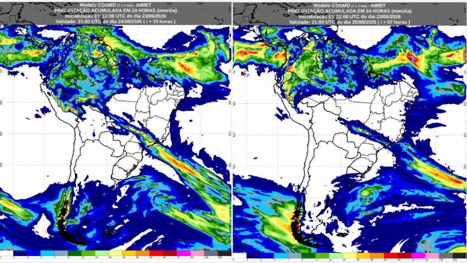
Between Tuesday (June 23) and Wednesday (June 24), the weather will stabilize and temperatures will drop throughout the Southern region of Brazil after the passage of the frontal system, formed last Monday (June 22). According to the National Institute of Meteorology (Inmet), the system is still active in areas of the Central-West region, particularly in the state of Mato Grosso do Sul, as well as southern Mato Grosso and Goiás. In the Southeast, the system brings the forecast of showers in areas of the state of São Paulo, Minas Gerais, and throughout the state of Rio de Janeiro.
The Northern region continues to experience areas of high instability, particularly in the states of Amazonas, Roraima, Macapá, Acre, and Pará. The Northeast, on the other hand, presents a contrast between rain showers along the coast, mainly in Maranhão, and stable weather in the interior of the region, with temperatures potentially reaching 35°C.
On Wednesday, the forecast indicates unstable weather patterns over much of the Northern Region, favoring the occurrence of showers, mainly in the states of Amazonas, Roraima, Macapá, and Acre. In Pará, the rain will be concentrated in the west of the state, in the Santarém region, as well as in the Belém region and the coast. The exceptions are Tocantins and the southeastern portion of Pará, where the forecast is for few clouds, with predominantly sunny skies and no rain.
On Thursday, the rain will be concentrated mainly in the central part of Amazonas, including the capital Manaus, western Pará, and Macapá. This rain is expected to come in the form of showers. In other areas of the region, cloud cover will prevail.
Minimum temperatures are expected in southern Rondônia, with values close to 18°C. In the rest of the region, minimum temperatures should vary between 21°C and 25°C. The highest maximum temperatures are forecast for Tocantins, potentially reaching 35°C. On Thursday, minimum temperatures should be around 16°C in Vilhena (RO), while maximum temperatures will be around 35°C in Araguaína (TO).
Between Wednesday and Thursday, rainfall is expected to be concentrated mainly along the coast, particularly in São Luís (MA), where 50mm/day is expected. On Wednesday, the entire state of Alagoas, Sergipe, and a large part of Pernambuco will experience rain, although in more isolated areas. In the interior of the region, no rain is expected, with predominantly stable weather throughout the period.
The lowest temperatures in the region are expected to be recorded in the interior of Bahia, with lows around 12°C. The highest highs are forecast for the interior of Piauí, where thermometers could reach 35°C.
This Wednesday, a frontal system moving through the Central-West region of Brazil will reach the states of Mato Grosso do Sul, Mato Grosso, and Goiás. This system will favor the occurrence of showers in northern Mato Grosso do Sul and southern Mato Grosso and Goiás. As a consequence of the advance of this frontal system, there will be an increase in cloud cover throughout the day.
On Thursday, unstable conditions will intensify over much of Mato Grosso do Sul. Therefore, heavier rain showers are also expected in the southern parts of the states of Mato Grosso and Goiás.
Minimum temperatures are expected to range between approximately 6°C and 17°C across much of the region. Maximum temperatures could reach 32°C in northern Mato Grosso. Notably, in the Federal District, minimum temperatures may register values below 16°C.
On Wednesday, the frontal system will move in, bringing favorable conditions for rain, as well as locally intense showers to the central and northern regions of the state of São Paulo, the Triângulo Mineiro region, southern Minas Gerais, and the entire state of Rio de Janeiro.
On Thursday, this instability is expected to continue. This system will bring heavy rain to the northern regions of São Paulo, southern Minas Gerais, the Paraíba Valley, and southern Rio de Janeiro, as well as part of the São Paulo metropolitan area.
Minimum temperatures are expected to reach values close to 11°C in the Serra da Mantiqueira mountain range, while in other areas of the region, values should vary between 13°C and 16°C. Maximum temperatures should vary between 19°C in southern Minas Gerais and 30°C in northern Rio de Janeiro and southern Espírito Santo.
Both on Wednesday and Thursday, the southern region of Brazil will experience predominantly stable weather throughout the day with no rain forecast. There is a possibility of frost at the start of both days.
After the passage of the frontal system, temperatures will remain lower compared to previous days. Minimum temperatures should range between -1°C in southern Paraná and 11°C in northern Paraná. Maximum temperatures should vary between 10°C in the Serra Gaúcha region and 15°C in Porto Alegre, possibly reaching 18°C in northern Paraná.
Receive the latest agriculture news by email


Receive the latest agriculture news by email