



Sicoob leads in rural credit disbursements in Santa Catarina.
Across the entire area served by Sicoob SC/RS, rural credit disbursements totaled R$ 12,6 billion in the 2025/26 harvest.
13.07.2026 | 17:31 (UTC -3)
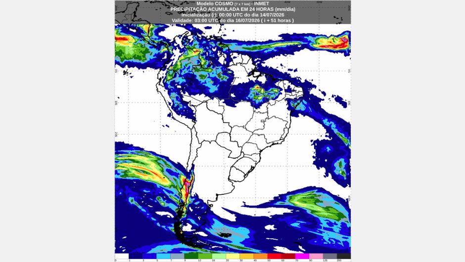
The National Institute of Meteorology (Inmet) released today (July 14th) the weather forecast for the next two days. On Wednesday (July 15th), the presence of a cold front over the Atlantic Ocean will favor rainfall from the southern coast of Bahia to Alagoas. Isolated showers are expected in Ceará, Piauí, and Maranhão.
In the North region, rainfall is concentrated mainly in Amazonas, Roraima, and Pará, while in other states it occurs in isolated areas. In the Central-West region, there is a possibility of isolated rain only in the far north of Mato Grosso. In other areas of the Central-West, Southeast, and South regions, the weather remains stable. The possibility of frost persists in southern Minas Gerais and the Campos do Jordão region (SP) during the early hours of Wednesday.
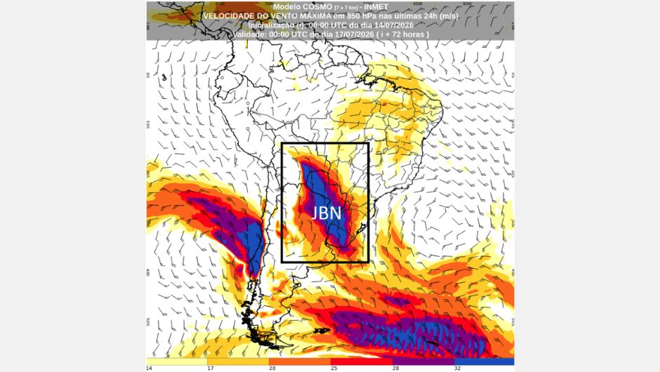
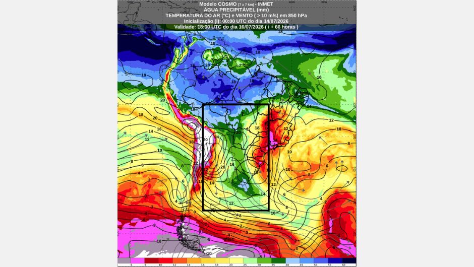
On Thursday (July 16th), the development of a low-pressure area in Argentina, associated with the transport of warm and humid air by the Low-Level Jet (LLJ), will favor the return of rain to Rio Grande do Sul. These conditions increase the potential for storms, which is why there is a warning of potential risk for storms in the west and south of Rio Grande do Sul, in municipalities such as Ijuí, São Borja, Alegrete, Santiago, Uruguaiana, Santa Maria, Bagé, Pelotas, Rio Grande, among others. In other areas of southern Brazil, the weather remains stable, but with increased wind speed and rising temperatures due to the influence of the LLJ.
On Wednesday, rainfall will be concentrated mainly in Amazonas and Pará, also remaining over Roraima. In the other states of the region, including northern Tocantins, Amapá, and Acre, precipitation will occur in isolated areas. On Thursday, conditions for rain and thunderstorms will persist in Amazonas, Roraima, and Pará. There is also a possibility of isolated rain in Tocantins, Amapá, and Acre. Minimum temperatures will remain around 20°C in the southern part of the North Region, while maximum temperatures will reach approximately 32°C.
On Wednesday, a cold front over the Atlantic Ocean will bring rain to north-central and eastern Bahia, Sergipe, and Alagoas. There is a warning for the coastal areas of Bahia, Sergipe, and Alagoas indicating a potential risk of heavy rainfall due to the advancing cold front. The rains will also intensify and extend to areas of Ceará, Piauí, and Maranhão.
On Thursday, the cold front will maintain rainy conditions in Alagoas, Pernambuco, and Paraíba, especially along the coast and in the Agreste region. In these areas, including the capitals Maceió and Recife, there is a warning of potential risk for heavy rain. Isolated rain is also forecast for Rio Grande do Norte, Ceará, and Maranhão.
The post-frontal high pressure system, moving behind the cold front, is favoring lower temperatures in Bahia, with minimums close to 10°C in the south-central part of the state, in municipalities such as Vitória da Conquista and Piatã. There is also a warning of low air humidity on Thursday for western Bahia, including municipalities such as Barreiras and Luís Eduardo Magalhães, as well as the extreme south of Piauí, in São Gonçalo do Gurguéia and Corrente, and southern Maranhão. Maximum temperatures will be around 35°C.
On Wednesday, the possibility of isolated rain occurs only in the far north of Mato Grosso. In other areas of the region, the weather remains stable, with varying cloud cover. On Thursday, the conditions for isolated rain are limited to the north and west of Mato Grosso. In other areas of the Central-West region, the weather remains stable.
There is a warning of potential risk for low air humidity on Thursday throughout the state of Goiás, the Federal District, and eastern Mato Grosso do Sul, with values between 20% and 30%. The mornings will be mild, with lows near 12°C in southern and eastern Mato Grosso do Sul and southern Goiás on Wednesday.
During the afternoon, highs reach 34°C in northwestern Mato Grosso do Sul, southern and eastern Mato Grosso, and northwestern Goiás. The Low-Level Jet intensifies winds in western Mato Grosso do Sul, potentially reaching 60 km/h in the Corumbá and Porto Murtinho regions.
The Southeast region remains under the influence of a post-frontal high-pressure system affecting the entire eastern part of the region, maintaining stable weather, without rain, and with low temperatures in the early mornings of Wednesday and Thursday. There is a forecast of humid fog in eastern São Paulo and Minas Gerais, and in the interior of the states of Rio de Janeiro and Espírito Santo in the early morning hours of Wednesday.
Minimum temperatures will occur in Minas Gerais, eastern São Paulo, and mountainous regions of Rio de Janeiro and Espírito Santo, with values around 8°C. In some areas, these temperatures will drop to 2°C, with a potential frost risk warning in southern Minas Gerais and the Campos do Jordão region of São Paulo. During the afternoons, temperatures will rise, with highs near 30°C in western São Paulo on Thursday.
It is also worth noting that there is a warning of potential risk for low air humidity on Thursday in much of São Paulo (except for the eastern strip and coast), as well as southern and western Minas Gerais, where values range between 20% and 30%.
On Wednesday, the cold air mass will weaken, but the weather will remain stable throughout the Southern Region, with no rain forecast. In the early morning hours, there may be damp fog in northeastern Rio Grande do Sul and eastern Santa Catarina and Paraná. Temperatures will rise throughout the afternoon, with highs exceeding 20°C in several locations.
On Thursday, the development of a low-pressure area in Argentina, combined with the Low-Level Jet (LLJ), favors the return of rain to the south and west of Rio Grande do Sul. There are conditions for storms, with a potential risk warning, covering municipalities such as Alegrete, Santiago, Uruguaiana, Bagé, Pelotas, and Rio Grande. In other areas of the Southern Region, the weather remains stable. In the early morning, there is a possibility of frost in southern Paraná. Minimum temperatures will be around 5°C.
Throughout the day, an increase in temperature and wind speed is expected due to the JBN's influence, with maximum temperatures of approximately 26°C in northern and western Paraná, western Santa Catarina, and northwestern and central Rio Grande do Sul.
On Thursday, the Low-Level Jet (LLJ) will be intense, stretching from Mato Grosso do Sul to the far south of Rio Grande do Sul, transporting a large amount of heat and moisture towards southern Brazil. This configuration is one of the main factors contributing to the formation of storms over Rio Grande do Sul.
Furthermore, the subtropical jet stream intensifies over the Pacific Ocean and approaches South America, reinforcing atmospheric circulation at high levels. This pattern is consistent with the coupling between positive sea surface temperature anomalies in the Equatorial Pacific, in response to the El Niño event, and large-scale atmospheric circulation, contributing to an environment favorable to the development of storms in Rio Grande do Sul.
Receive the latest agriculture news by email


Receive the latest agriculture news by email