



Solon Cordeiro assumes the position of Emeritus Advisor of Anpii Bio.
The organization's founder will continue contributing to the development of bio-inputs and the association.
10.07.2026 | 16:21 (UTC -3)
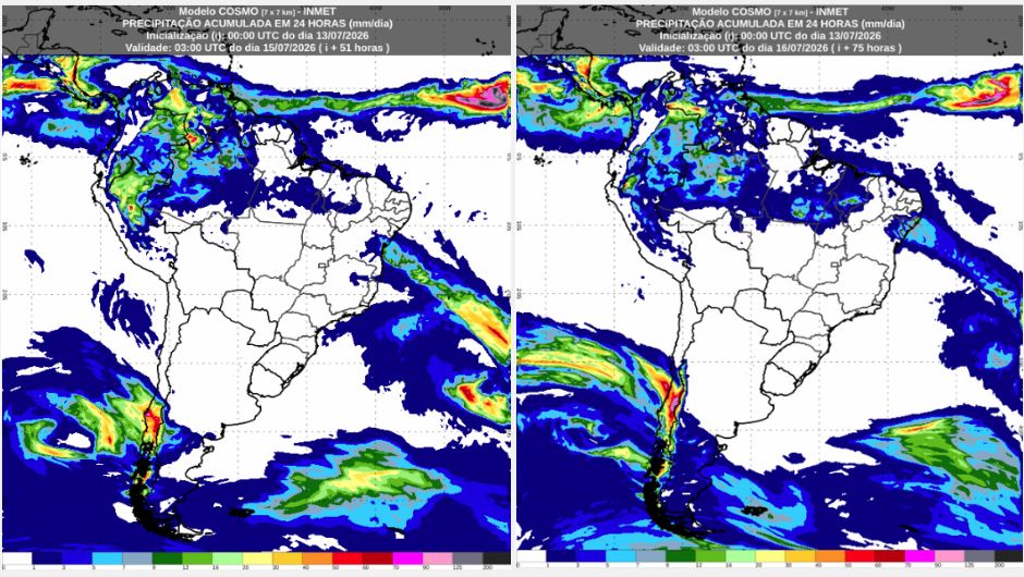
The weather forecast from the National Institute of Meteorology (Inmet) indicates that, between Tuesday (14) and Wednesday (15), the action of a low pressure system over the Atlantic Ocean organizes a frontal system that favors the occurrence of rain from the southern coast of Bahia to the state of Alagoas, especially on Wednesday (15), when the precipitation gains intensity in the Northeast, and also covers the states of Ceará, Piauí and Maranhão.
In the North Region, rain is mainly concentrated in Amazonas, Roraima and Pará, while in the other states it occurs in an isolated manner. In the Central-West there is a possibility of isolated rain in the Federal District on Tuesday, and in the extreme north of Mato Grosso on Wednesday. In the other areas of the Central-West, Southeast and South regions, the weather remains stable, with frost forecast in the South Region on Tuesday (14), while in the south of Minas Gerais and in the Campos do Jordão region, in São Paulo, frost may occur both on Tuesday (14) and on Wednesday (15).
On Tuesday (14), there is a forecast of rain accompanied by isolated thunderstorms in Roraima, Amazonas and Pará. In Acre, Rondônia and Tocantins, the weather will be mostly dry, while in other areas of the region there may only be light and isolated rain.
On Wednesday (15), rainfall will be concentrated mainly in Amazonas and Pará, remaining quite isolated in the other states, including the north of Tocantins. Regarding temperatures, minimums around 20°C in the south of the North region, and maximums around 32°C throughout the region.
On Tuesday (14), a frontal system over the Atlantic favors isolated rains on the southern coast of Bahia and in the metropolitan region of Salvador. In addition, the heat associated with local effects causes weak and isolated showers in the interior of Ceará, Piauí and Maranhão. In other areas of the region, the weather remains stable. On Wednesday (15), the rains intensify between the north-central and eastern parts of Bahia, Sergipe, Alagoas, Ceará, Piauí and Maranhão, stimulated by the passage of the frontal system over the Ocean. In the other states of the Northeast, the rain occurs in an isolated manner.
On the southern coast of Bahia, between Itacaré and Porto Seguro, there is a warning of potential risk for coastal winds on Tuesday (14). On Wednesday (15), the wind gains intensity over part of the Northeast, with a warning of potential risk for strong winds between the central-east of Bahia, Pernambuco, Sergipe, Alagoas, south of Ceará, south of Paraíba and the border between Piauí and Pernambuco. Minimum temperatures around 15°C in mountainous regions of Bahia. Maximum temperatures around 35°C in the interior of the Northeast.
Tuesday (14) with predominantly stable weather in the Central-West region. However, the presence of the frontal system in the Atlantic Ocean may favor increased cloudiness in the region, and cause isolated and generally weak rain in the Federal District and Goiás. On Wednesday (15), the possibility of isolated rain occurs mainly in the extreme north of Mato Grosso. In the other areas of the central-west, the weather will be stable, but with varying cloudiness. Cold dawn in Mato Grosso do Sul and southern Goiás, with minimum temperatures around 10°C on Tuesday and 12°C on Wednesday.
High maximum temperatures in the north of the region, around 34°C in Mato Grosso and Goiás. Also noteworthy is the potential risk warning for low humidity on Tuesday (14) in eastern Mato Grosso do Sul, including the Três Lagoas region, and in southern Goiás, covering Jataí, Rio Verde, Caldas Novas and Itumbiara. In these areas, humidity levels will be between 20% and 30% during the afternoon.
On Tuesday (14), humid winds blowing from the ocean will favor weak and isolated rains on the coast of São Paulo and Rio de Janeiro. In the northeast of Minas Gerais there may be isolated rain due to the presence of the frontal system in the Atlantic Ocean. In the other areas of the Southeast, the weather remains stable. There is a warning of potential risk for low humidity between the west and north of São Paulo, including the municipalities of Presidente Prudente, Araçatuba, São José do Rio Preto, Ribeirão Preto, Votuporanga and Araraquara, as well as the Triângulo Mineiro, such as in Uberaba and Uberlândia, and the south of Minas Gerais, including Passos and Lavras.
There is also a warning of potential risk for coastal winds along the northern coast of Rio de Janeiro and the coastal strip of Espírito Santo, including the Espírito Santo municipalities of São Mateus, Serra, Vitória, and Guarapari. Cold temperatures are expected in the early mornings of Tuesday and Wednesday, with temperatures below 10°C in much of São Paulo and Minas Gerais, as well as in the mountainous regions of Rio and Espírito Santo. Isolated frosts are expected in southern Minas Gerais, in municipalities such as Poços de Caldas, Pouso Alegre, and Maria da Fé, as well as in the Campos do Jordão region of São Paulo. Temperatures will rise during the afternoons, with highs around 30°C in northern Minas Gerais and 26°C in western São Paulo, mainly on Wednesday.
The presence of cold and dry air mass over the Southern region of Brazil maintains stable weather on Tuesday (14) throughout the region. Temperatures remain low during the early morning and at dawn, with values between 0°C and 4°C, favoring the occurrence of frost in several areas of the region. As a result, there is a warning of potential risk for frost in south-central Paraná, including Ponta Grossa, Guarapuava, Castro, São Mateus do Sul, General Carneiro, Palmas and Clevelândia; in much of Santa Catarina, especially São Joaquim, Urubici, Lages, Rio do Sul, Ituporanga, Curitibanos, Campos Novos, Joaçaba, Chapecó, São Miguel do Oeste, Caçador and Major Vieira; and in the north, center and countryside of Rio Grande do Sul, in locations such as Caxias do Sul, Passo Fundo, Santo Ângelo, Santa Maria, Santa Cruz do Sul, Novo Hamburgo, Bagé and Santana do Livramento.
On Wednesday (15), the cold air loses intensity, but the weather remains stable throughout the Southern Region, with no rain forecast and no frost forecast. Maximum temperatures on Wednesday exceed 20°C in several locations in the region.
Receive the latest agriculture news by email


Receive the latest agriculture news by email