



Viruses and parasitoid venom alter arthropods
Field trial links components of Cotesia glomerata to herbivore and parasitoid colonization
09.08.2026 | 14:26 (UTC -3)
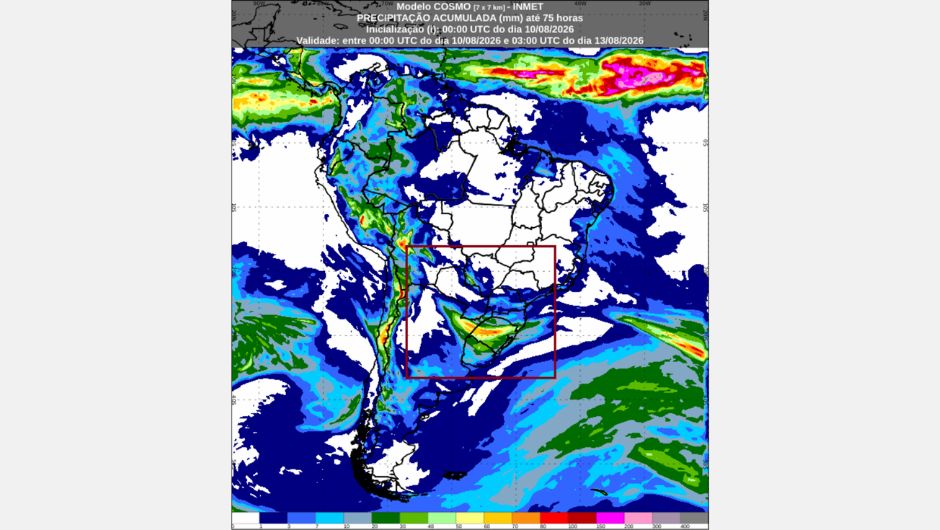
The presence of a surface trough (an elongated region of low pressure) between Paraguay, northern Argentina, and southern Brazil will favor the formation of new areas of instability over southern Brazil, which may cause new storms in the region. This is according to the forecast from the National Institute of Meteorology (Inmet) for Tuesday (August 11) and Wednesday (August 12).
On Tuesday, isolated showers and thunderstorms are expected between Paraná, Santa Catarina, and northwestern Rio Grande do Sul. On Wednesday, the unstable weather systems, moving towards Rio Grande do Sul and south-central Santa Catarina, will maintain conditions for rain and thunderstorms.
In the North region, rainfall is more concentrated in western Amazonia, while in the Northeast there is a greater chance of rain along the coast and in Maranhão. In the Southeast, cloud cover remains more concentrated in the eastern strip, with the possibility of isolated rain in São Paulo, Rio de Janeiro, Espírito Santo, and eastern Minas Gerais. In central Brazil, the weather remains predominantly dry, with few clouds, high temperatures, and low humidity levels, especially in the Central-West, southern Amazonia, and areas of Matopiba (an agricultural region located between Maranhão, Tocantins, Piauí, and Bahia).
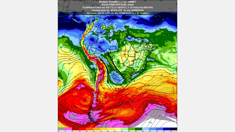
The Northern Region will experience a higher concentration of instability in western Amazonia and along the coastal strip between Pará and Amapá. For Tuesday morning and afternoon, isolated showers and thunderstorms are forecast for western Acre and Amazonas, as well as eastern Amapá and the coastal strip of Pará. Showers are also expected in eastern Acre, northwestern Roraima, and western Rondônia, with the possibility of isolated rain in northwestern Rondônia. During the night, instability will persist in western Acre and west-central Amazonas, as well as eastern Amapá and the coastal strip of Pará.
On Wednesday, cloudy skies with showers and isolated thunderstorms are expected between western and northern Amazonas and northwestern Roraima. Showers are also forecast for other areas of Roraima and western Acre, with the possibility of isolated rain in other areas of Amazonas, except in the southeast of the state, much of Acre, the far north of Rondônia, eastern Amapá, and northeastern Pará, mainly along the coast.
In southern Pará and Tocantins, there are predominantly few clouds, intense heat, and low air humidity. Therefore, for Tuesday, there is an orange warning for low humidity in southern Pará and south-central Tocantins, including Palmas (TO). There is also a yellow warning for potentially dangerous low humidity in eastern Rondônia, southern Pará and Tocantins, and a yellow warning for potentially dangerous strong winds in southern and southeastern Tocantins.
The warnings indicate low humidity and strong winds, which, combined with the intense heat, may favor the occurrence and spread of wildfires in the region.
Temperatures remain high throughout the region. Lows may reach 22°C in Rio Branco (AC) and Palmas (TO), while highs may reach 38°C in Palmas (TO).
The forecast indicates a higher concentration of clouds and rain in the eastern part of the entire Maranhão region. For Tuesday morning, there is a forecast of showers with isolated thunderstorms in the north-central and northwest of Maranhão. In the eastern part of the Northeast, mainly in areas near the coast between Bahia and Rio Grande do Norte, showers are expected. There is also a possibility of isolated rain in areas of the Agreste region. During the afternoon/evening, instability will persist in north-central Maranhão, northern Piauí, and the southern coast of Bahia, where there are conditions for showers and isolated thunderstorms. In addition, there is a possibility of isolated rain along the coastal strip between Salvador (BA) and Natal (RN).
On Wednesday, there is a forecast of showers on the eastern coast of Bahia and Sergipe, as well as the possibility of isolated rain in other areas of the coastal strip. Inland, few clouds, intense heat and low air humidity will prevail throughout the period.
On Tuesday, there is a yellow warning for potential danger of strong winds in southern Piauí, southwestern Pernambuco, and west-central Bahia. There is also a yellow warning for potential danger of low air humidity in south-central Maranhão, south-central Piauí, south-central Ceará, western Paraíba, western Pernambuco, and northern and western Bahia. The conditions of low humidity and the occurrence of strong winds are concentrated mainly in the interior of the region.
Temperatures remain high in the interior of the Northeast. Minimum temperatures can reach 22 °C in Maceió (AL) and Recife (PE), while Fortaleza (CE) remains with high temperatures, even during the nights and early mornings, with a minimum of 26 °C. The maximum can reach 36 °C in Teresina (PI).
The Central-West Region will remain with predominantly stable and dry weather. However, on Tuesday, there should be many clouds in Mato Grosso do Sul and western Mato Grosso, due to a moisture channel passing through the region, but it will not bring rain. On Wednesday, few clouds will prevail throughout the region, with dry and hot weather.
On Tuesday, there is an orange warning for low humidity in central-eastern Mato Grosso and almost all of Goiás state. There is also a yellow warning for potentially dangerous low humidity in other areas of Mato Grosso, northern Mato Grosso do Sul, Goiás, and the Federal District. A further yellow warning for potentially dangerous strong winds is in effect in northeastern Goiás.
Temperatures remain high, especially during the afternoon. The minimum temperature could reach 16 °C in Brasília (DF) and Goiânia (GO), while the maximum could reach 35 °C in Cuiabá (MT).
For the Southeast region, cloudy conditions are expected in the eastern part of the region, with the possibility of isolated showers in areas near the coast. On Tuesday, cloud cover will predominate in the region, with isolated showers and thunderstorms on the southern coast of São Paulo, as well as showers in Rio de Janeiro and eastern Espírito Santo, in addition to the possibility of isolated showers in eastern São Paulo. In western and northwestern Minas Gerais, the condition is mostly clear throughout the day. During the night, cloud cover will increase in eastern Minas Gerais, with the possibility of isolated showers, as well as conditions for isolated showers in eastern São Paulo, Rio de Janeiro, and Espírito Santo.
On Wednesday, many clouds will remain in the eastern part of the region, with the possibility of isolated rain on the northern coast of São Paulo, the coast of Rio de Janeiro, and the coast of Espírito Santo. In Minas Gerais, many clouds will predominate in the eastern part of the state, while the west of the state, and the central-west and north of São Paulo, will remain with few clouds. On Tuesday, there is a yellow warning of potential danger due to low humidity in western Minas Gerais.
Temperatures vary greatly across the region. São Paulo (SP) will have a minimum of 13 °C and a maximum of 16 °C on Tuesday, maintaining cold weather in the eastern part of the state. On Wednesday, temperatures will rise in the interior of the region, with a maximum of 29 °C in Belo Horizonte (MG).
Areas of instability are intensifying again over the southern region of Brazil, due to the presence of a trough acting between Paraguay, northern Argentina, and southern Brazil. In the eastern part of the region, temperatures remain low. Tuesday dawns with conditions for frost in the central-eastern part of Rio Grande do Sul, except for the coastal strip, and in the Serra Catarinense. Throughout the morning, many clouds will move over the region, with forecasts of showers and isolated thunderstorms between south-central Paraná, Santa Catarina, and northwestern Rio Grande do Sul. In northern Paraná and other areas of Rio Grande do Sul, many clouds will predominate, but without rain. During the afternoon and evening, instability will persist between south-central Paraná, Santa Catarina, and northwestern Rio Grande do Sul.
On Wednesday, cloud cover will increase in Rio Grande do Sul, and instability will prevail over the state and south-central Santa Catarina, with isolated rain and thunderstorms. There is also a possibility of isolated rain in other areas of Santa Catarina and the extreme south of Paraná, while most of Paraná will remain with stable weather and few clouds, especially in the north of the state.
On Tuesday, there is a yellow warning of potential danger for storms in western and central Santa Catarina, in municipalities such as Chapecó (SC), São Miguel do Oeste (SC), Concórdia (SC), Joaçaba (SC) and Campos Novos (SC), and in western and northern Rio Grande do Sul, in municipalities such as Lagoa Vermelha (RS), Passo Fundo (RS), Erechim (RS), Cruz Alta (RS), Santo Ângelo (RS), São Borja (RS) and Santa Rosa (RS). The possibility of severe weather in the region cannot be ruled out.
The cold weather remains intense in the eastern part of the region. On Tuesday, minimum temperatures could reach 8°C in Curitiba (PR) and Porto Alegre (RS), while the maximum temperature should not exceed 10°C in Curitiba (PR). On Wednesday, the maximum temperature will not exceed 15°C in Curitiba (PR) and 19°C in Florianópolis (SC), while in Porto Alegre (RS) the maximum temperature will not exceed 16°C on both days.
Receive the latest agriculture news by email


Receive the latest agriculture news by email