



Bahia government extends Proalba until 2028.
Bahia Cotton Producers Association celebrates decision published in the DOEBA this Tuesday (June 30th)
30.06.2026 | 17:40 (UTC -3)
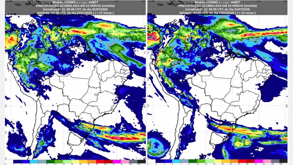
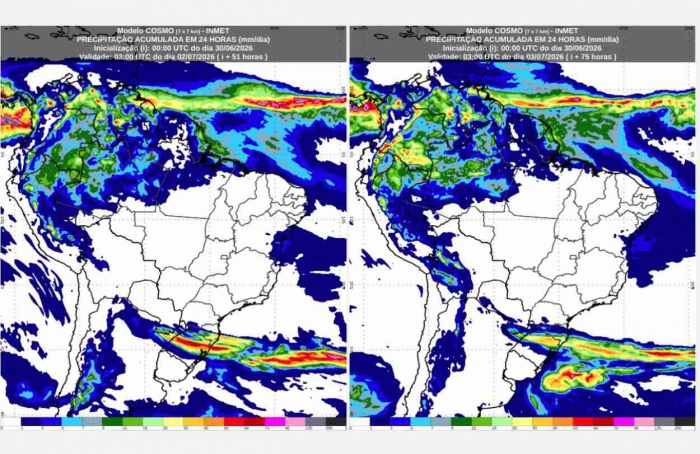
Rain is expected to continue causing havoc in the South of the country. This is according to the National Institute of Meteorology (Inmet). On Thursday (July 2nd) and Friday (July 3rd), the forecast remains for intense rain with lightning, wind gusts that could exceed 80 km/h, and the possibility of hail in areas of the states of Rio Grande do Sul and Santa Catarina.
These conditions are predicted due to the presence of a stationary front and the behavior of winds in the upper layers of the atmosphere. Rain is expected to primarily affect locations in north-central Rio Grande do Sul, Santa Catarina, and areas of southern and southwestern Paraná throughout Thursday and into the early morning hours of Friday. As Friday progresses, the likelihood of severe storms is expected to decrease over the states in the region.
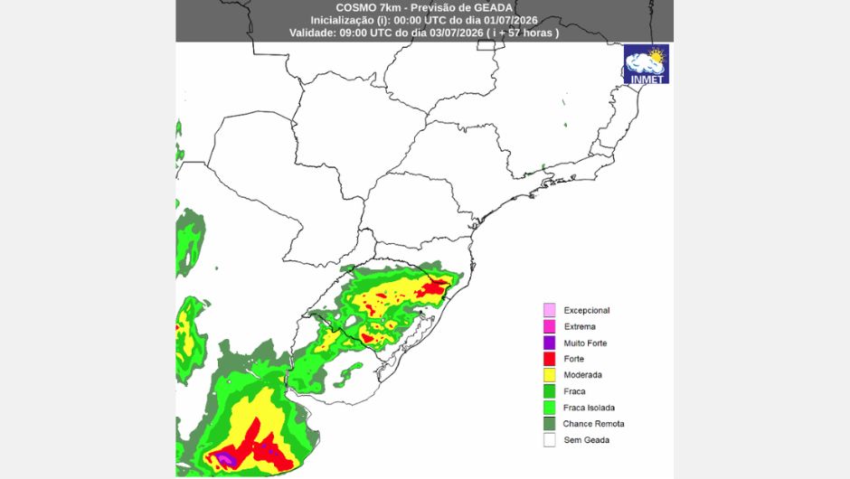
Temperatures are expected to drop, especially in the southern region of the country, with frost forecast between Santa Catarina and Rio Grande do Sul during this period due to the presence of a cold air mass.
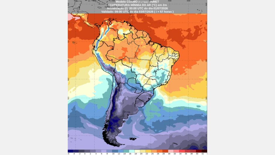
On Thursday, conditions persist for isolated showers with thunderstorms and gusts of wind over areas of western and northern Amazonas, Roraima, Amapá, Marajó Island, northwestern and northeastern Pará, and, from the afternoon onwards, over western Acre. Minimum temperatures are expected to be around 13°C and maximum temperatures between 36°C and 38°C. Minimum air humidity will remain between 30% and 20% in areas of Tocantins, Rondônia, and southern Pará, where the weather should remain stable.
On Friday, the heaviest rain is expected to be concentrated in the northern part of Amazonas. In the northern part of Pará, Amapá, Roraima, and western Acre, rainfall will be brief and localized, mainly from the afternoon onwards. Temperatures will remain stable with lows around 13°C and highs between 35°C and 37°C. Minimum air humidity will remain below 30% in Tocantins and southern Pará.
On Thursday and Friday, most of the region, especially inland, will remain without rain. In the eastern part of the region, there will be slightly more cloud cover due to moisture transport from the ocean. In some coastal areas, between Rio Grande do Norte and Bahia, light and isolated showers are possible. Inland areas will continue to experience low air humidity, with values between 30% and 20%, mainly in the Sertão region. Minimum temperatures should range from 11°C to 13°C, and maximum temperatures will be around 34°C and 36°C.
On Thursday and Friday, the weather will remain stable, with no rain forecast for the states in the region. Temperatures are expected to drop slightly in areas of western and southern Mato Grosso, especially on Friday, when a cold air mass is expected to move slightly through the western part of the region. Minimum humidity is expected to vary between 30% and 20% in all states during the afternoon. Minimum temperatures will range between 7°C and 9°C, and maximum temperatures between 34°C and 36°C.
On Thursday, the weather will remain stable, with no rain forecast, throughout the Southeast Region due to the presence of a high-pressure system. Minimum temperatures will range between 8°C and 10°C in southern Minas Gerais, while maximum temperatures will remain around 32°C in western São Paulo and Rio de Janeiro. The day will begin with relative humidity values around 90% to 95%, reducing to values between 35% and 40% during the afternoon, with the lowest values expected for western São Paulo and southern Rio de Janeiro.
On Friday, the passage of a cold front near the coast and the influx of humid air from the ocean into the continent will favor isolated showers in Rio de Janeiro and the eastern part of the state of São Paulo. Conversely, the weather will remain stable in Espírito Santo, Minas Gerais, and the central-western part of São Paulo state, including the metropolitan region.
Temperatures are starting to drop compared to Thursday, with lows between 6°C and 8°C in southern Minas Gerais. Highs will be around 30°C in western São Paulo, between 14 and 16°C in central-eastern São Paulo, and around 23°C in Rio de Janeiro. The day begins with relative humidity values around 90% to 95%, reducing to between 35% and 40% during the afternoon throughout the region except for the coast between São Paulo and Rio de Janeiro. In these areas, relative humidity remains above 80% throughout the day.
On Thursday, persistent instability will favor the occurrence of strong storms from southern Paraná, encompassing Santa Catarina and north-central Rio Grande do Sul. Due to the predicted conditions, there is a warning of very dangerous accumulated rainfall valid for the entire day on Thursday.
This intense rainfall could reach volumes exceeding 60 mm/h or 100 mm/day. There is also a forecast of strong winds along the coast of Rio Grande do Sul, which could reach speeds around 60 km/h. Due to the arrival of a polar air mass, minimum temperatures will be around 2°C in the far south of Rio Grande do Sul, while maximum temperatures will be between 28 and 30°C in the far northwest of Paraná.
On Friday, the weather should stabilize across almost the entire region, except for the coast of Paraná and Santa Catarina between morning and afternoon, where isolated showers are expected due to the arrival of a high-pressure system over the area. In addition to stability, the arrival of the high-pressure system will bring lower temperatures and the possibility of frost between Santa Catarina and Rio Grande do Sul. Negative temperatures are expected in Rio Grande do Sul and the Serra Catarinense region, with isolated highs of up to 24°C in the far northwest of Paraná.
Receive the latest agriculture news by email


Receive the latest agriculture news by email