



Nanoformulation enhances emamectin action in study
A strategy using acetic acid reduced particles to 7 nanometers and increased penetration into leaves and roots
14.06.2026 | 15:50 (UTC -3)
The week between June 15th and 22nd will be marked by continued rainfall in the North Region and the influence of cold fronts in the Central-South of the country, which should cause a drop in temperatures and favor precipitation in producing areas of the South and Southeast regions. The forecast was released this Monday (June 15th) by the National Institute of Meteorology (Inmet).
The heaviest rainfall is expected between Amazonas, Roraima, Amapá, and northern Pará. Precipitation is also forecast along the northeastern coast and in states in the South and Southeast regions, especially Santa Catarina, Paraná, São Paulo, and Rio de Janeiro.
According to Inmet, the country will continue to be divided between two distinct temperature patterns. While areas of the Central-West, North, and part of the Northeast will continue to register intense heat, with highs above 36°C, the advance of cold air masses will keep temperatures lower between Rio Grande do Sul and Minas Gerais.
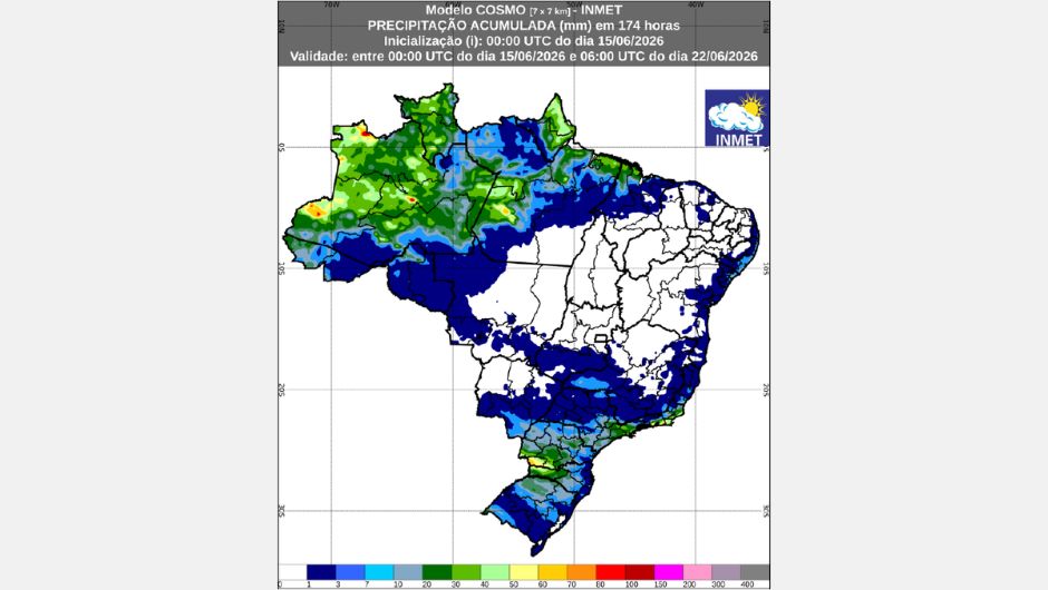
Na Northern RegionRainfall totals could exceed 100 mm throughout the week, mainly in western Amazonas. In central areas of the state, western Pará, and the coast of Amapá, volumes could reach 60 mm. In Roraima and the coast of Pará, accumulations should be around 40 mm, while Acre and Rondônia will have more modest rainfall, up to 30 mm. In Tocantins, the weather remains stable.
Temperatures will drop slightly, with lows between 20°C and 22°C. The highest highs are expected in southern Pará, northern Tocantins, and northeastern Maranhão, starting the week near 38°C and receding to around 34°C in the following days.
The coastal strip of Northeast Light and isolated rains are expected throughout the week, reaching areas of Ceará, Rio Grande do Norte, Paraíba, Pernambuco, Alagoas, Sergipe, and Bahia. In Maranhão, especially in the northwestern portion, rainfall amounts may exceed 40 mm.
Temperatures are expected to vary little. Minimum temperatures will remain above 20°C in most of the region, except for the interior of Bahia and the Agreste region of Pernambuco, where they may range between 14°C and 16°C. Maximum temperatures are expected to reach 36°C in north-central Piauí and western Rio Grande do Norte.
The forecast for the Midwest The forecast indicates isolated showers with low accumulations in western Mato Grosso, south-central Mato Grosso do Sul, southern Goiás, and the Federal District. In Goiás and the Federal District, dry weather will prevail from June 17th onwards. In Mato Grosso do Sul, the most significant rainfall is expected between the 19th and 20th.
The lowest temperatures are expected in eastern Mato Grosso do Sul and southern Goiás, with lows between 12°C and 14°C, especially in the early morning of the 18th. In other areas, minimum temperatures will range between 22°C and 24°C. Maximum temperatures may reach 38°C in northern Mato Grosso, maintaining the prevailing heat across much of the region.
No SoutheastThe passage of a cold front will bring rain to the entire state of São Paulo, south-central Minas Gerais, Rio de Janeiro, and Espírito Santo between June 15th and 16th. Between the 17th and 18th, rainfall is expected to concentrate in Rio de Janeiro and Espírito Santo. From the 20th onwards, new instabilities should bring back the rains, mainly to south-central São Paulo and western Rio de Janeiro.
Temperatures are expected to gradually decrease throughout the week. Lows could reach 10°C in southern Minas Gerais and southwestern São Paulo, spreading to other areas of the region. In much of the Southeast, minimum temperatures should remain below 14°C. Maximum temperatures will remain above 26°C, but in northern Minas Gerais they may even exceed 30°C. In São Paulo and Rio de Janeiro, temperatures should not exceed 24°C on most days.
No Sul In the country, the beginning of the week will see light and isolated rains on the coast of Paraná and Santa Catarina, while the rest of the region should experience dry weather. Between the 18th and 20th, new areas of instability will favor precipitation in Rio Grande do Sul, Santa Catarina, and Paraná, with accumulations exceeding 50 mm in parts of western Santa Catarina and southwestern Paraná.
Cold weather continues to prevail. In Rio Grande do Sul, minimum temperatures are expected to be below 6°C, with the possibility of temperatures close to 0°C in some locations. In Santa Catarina and Paraná, the cooling will be more intense between Wednesday and Thursday. Maximum temperatures will remain below 22°C and, in much of the region, should not exceed 18°C. The trend is for a slight increase in temperatures starting on Friday.
Receive the latest agriculture news by email


Receive the latest agriculture news by email