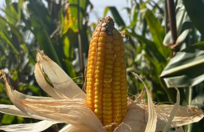




July will bring irregular rainfall and above-average heat to Brazil.
Inmet's forecast highlights high rainfall in the South and above-normal temperatures across the country.
01.07.2026 | 17:01 (UTC -3)
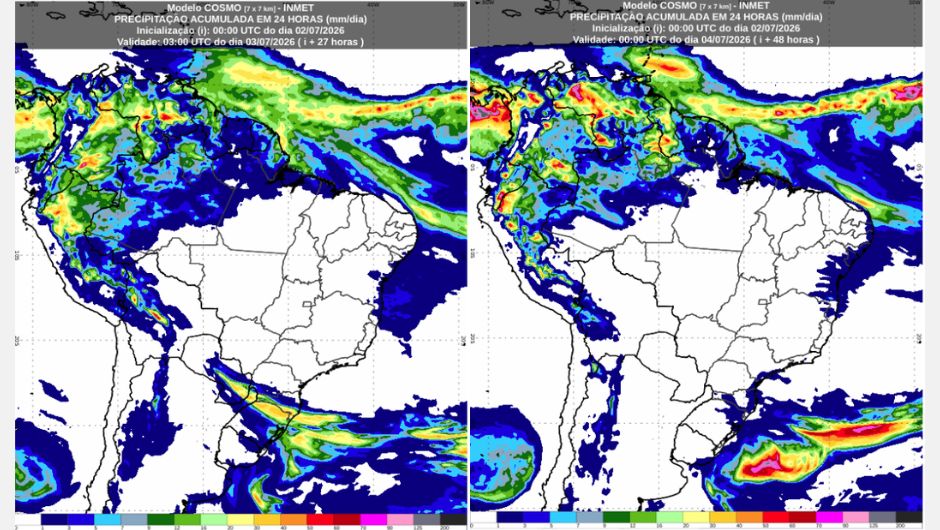
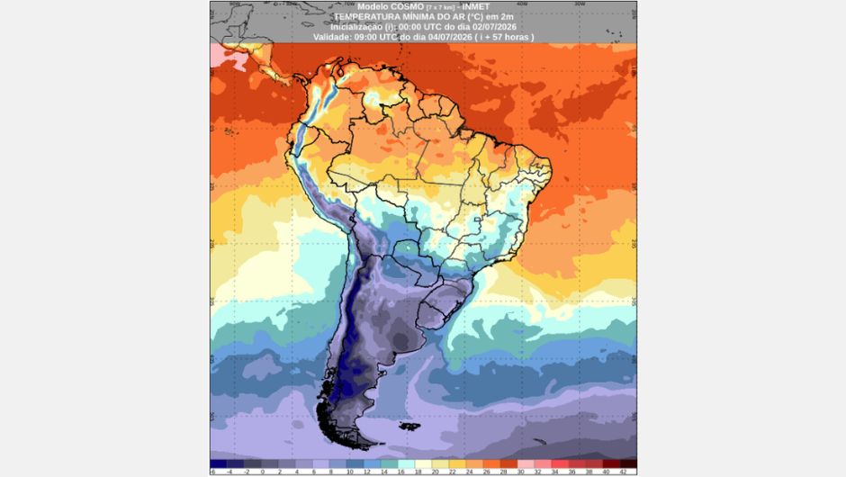
The National Institute of Meteorology (Inmet) predicts the advance of a cold front over the Southern Region starting this Friday (July 3rd). Behind the system, a mass of polar air will drop temperatures in several areas of the country. On Saturday (July 4th), the cold will continue to prevail, especially in the southern states, where minimum temperatures may reach between -5°C and -8°C in locations in Rio Grande do Sul and Santa Catarina.
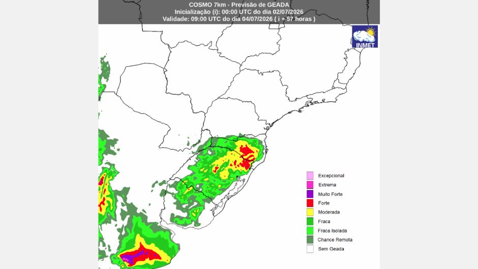
In addition to the Southern Region, the cooling also reaches Mato Grosso do Sul, the south and central-west of Mato Grosso, and part of the southwest of the Amazon, characterizing a new cold snap. Minimum temperatures will be below 0°C in areas of south-central Rio Grande do Sul, especially in the Campanha Gaúcha region, where frost is forecast.
Between dawn and the early morning hours, widespread frost is expected in various locations in the South. The cold weather is also advancing over areas in the eastern part of the Southeast Region. Throughout Saturday, maximum temperatures will begin to rise gradually in much of the South and in areas of Mato Grosso do Sul and Mato Grosso.
Over the next two days, strong winds associated with the extratropical cyclone linked to the cold front are expected to hit the coastal strip, mainly between the coast of Rio Grande do Sul and Santa Catarina, causing rough seas and high surf.
On Friday and Saturday, especially during the afternoon, the heat and high humidity will maintain the formation of isolated showers, accompanied by lightning and gusts of wind in the northern part of the region. The most affected areas will be western and north-central Amazonas, Roraima, Amapá, and the northern strip of Pará. No rain is expected in other areas.
Temperatures remain stable across most of the region, but the highlight is the start of a cold spell in Rondônia, Acre, and southwestern Amazonas, where minimum temperatures may drop to between 12°C and 13°C. Maximum temperatures reach 36°C and 37°C. Relative humidity remains below 30% in Tocantins and southern Pará.
Hot and dry weather will prevail in the interior of the region during the next two days, with relative humidity between 20% and 30%. Along the coast, especially between Rio Grande do Norte and Paraíba, light to occasionally moderate rain is possible.
Minimum temperatures range between 12°C and 14°C, while maximum temperatures reach between 34°C and 35°C.
The weather will remain stable with no rain forecast in all states on Friday and Saturday. During the afternoon, relative humidity should vary between 20% and 30%, mainly in Mato Grosso, Goiás, and the Federal District, maintaining hot and dry weather. Maximum temperatures will range between 34°C and 36°C.
In Mato Grosso do Sul, the arrival of cold air increases the chances of frost on Saturday morning. Minimum temperatures are expected to range between 2°C and 4°C.
On Friday, the passage of a cold front near the coast and the influx of moisture from the ocean will favor isolated showers in Rio de Janeiro and the eastern part of São Paulo. There is also a forecast of stronger winds in these areas, with a warning of potential danger from coastal winds.
The weather remains stable in Espírito Santo, Minas Gerais, and the central-western part of São Paulo state. Minimum temperatures range between 6°C and 8°C in southern Minas Gerais. Maximum temperatures reach 30°C in western São Paulo state, are between 16°C and 18°C in central-eastern São Paulo, and reach around 26°C in Rio de Janeiro. Relative humidity starts the day between 90% and 95% and drops to values between 35% and 40% during the afternoon, except on the coast between São Paulo and Rio de Janeiro, where it remains above 80%.
On Saturday, humid winds from the ocean will maintain conditions for isolated showers along the coast of São Paulo and Rio de Janeiro. Strong winds will be more restricted to the coast of Rio de Janeiro, where a potential danger warning remains in effect. There is also a possibility of light rain in the far north of Espírito Santo and Minas Gerais. In other areas, the weather will remain stable, with varying cloud cover.
Minimum temperatures will range between 5°C and 7°C in southern Minas Gerais, the Paraíba Valley, and the São Paulo Metropolitan Region. Maximum temperatures will reach around 28°C in northwestern São Paulo state, Minas Gerais, and the far north of Espírito Santo state, while on the São Paulo coast they should not exceed 16°C. Relative humidity will remain at levels similar to those recorded on Friday.
On Friday, the advance of a high-pressure system will favor more stable conditions and gradually reduce the occurrence of rain. There is still a possibility of isolated showers in the morning on the coast of Rio Grande do Sul, in the central-eastern part of Santa Catarina, and in the extreme south of Paraná. From the afternoon onwards, the instability will be restricted to Paraná.
The arrival of the cold air mass is causing a sharp drop in temperatures and favoring the occurrence of frost in much of Rio Grande do Sul. Inmet (National Institute of Meteorology) has issued orange-level warnings for intense cold and frost, as well as a yellow alert for coastal winds along the entire coastline of the region. Gusts could reach approximately 50 km/h. Minimum temperatures will be below freezing in areas of Rio Grande do Sul and the Serra Catarinense mountain range, while maximum temperatures may reach 24°C only in the extreme northwest of Paraná.
On Saturday, the weather will remain stable across most of the Southern Region. Only isolated showers are expected between the coast of Paraná and the Florianópolis Metropolitan Region. In other areas, the chance of rain is low, with varying cloud cover throughout the day.
Minimum temperatures will remain below freezing in the mountain ranges of Rio Grande do Sul and Santa Catarina, where conditions continue to be favorable for frost formation. In most of the region, maximum temperatures should not exceed 14°C. The exception is the extreme northwest of Paraná, where thermometers may reach between 24°C and 26°C.
Receive the latest agriculture news by email


Receive the latest agriculture news by email