




Inmet: weather forecast for Thursday (27) and Friday (28)
Unstable weather is expected in the Southeast and South regions, while temperatures rise across much of the country.
26.08.2026 | 16:51 (UTC -3)
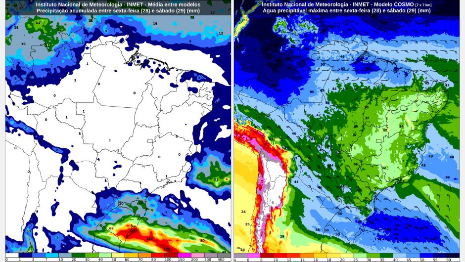
Friday (August 28) and Saturday (August 29) will have different weather conditions across the country's regions. While the trough at medium and high levels that has been active over the Central-West and Southeast regions in recent days is losing strength and moving towards the Atlantic Ocean, reducing instability in these areas, the intensification of another trough over the Southern Region and the formation of a low-pressure area increase the risk of storms.
In the South, the situation requires greater attention, especially in Rio Grande do Sul and Santa Catarina, where there is a possibility of heavy rain, storms, and hail. The National Institute of Meteorology (Inmet) also highlights the rise in temperatures across much of the country.
In the North and Northeast regions, instability remains weaker. The forecast indicates the possibility of isolated showers along the Northeast coast and in parts of the North region, mainly in Amazonas and Roraima. In Matopiba and much of the Central-West, the weekend begins with more stable weather and higher temperatures.
On Friday, instability will be concentrated between the central-west and northern Amazonas and in Roraima, where showers are expected. There is also a possibility of isolated rain in Amapá, northern and western Pará, other areas of Amazonas and Roraima, and northern Rondônia. In south-central Tocantins, dry weather persists with few clouds. In other areas, there will be many clouds, but no rain. There is a yellow warning for potential danger of heavy rain in the central-west and northern Amazonas, and a yellow warning for potential danger of low air humidity during the afternoon in southeastern Pará and Tocantins.
On Saturday, isolated showers are expected in the central-west and north of Amazonas, in Roraima, in northern Rondônia, in northern and western Pará, and in southwestern Amapá. In Tocantins, few clouds are expected, and in other areas, many clouds but no rain. A yellow warning of potential danger due to low air humidity is in effect in southern Rondônia, southeastern Pará, and Tocantins.
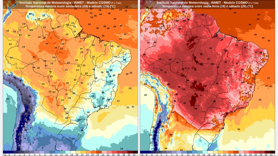
Regarding temperatures, among the capital cities, the minimum will be 22°C in Rio Branco (AC), and the maximum, 38°C in Palmas (TO) and Porto Velho (RO).
Friday begins with fog on the southern coast of Bahia and many clouds across much of the region. During the afternoon, isolated showers are expected along the northeastern coast, mainly between the coast of Ceará, Rio Grande do Norte, Paraíba, Pernambuco, Alagoas, Sergipe, and the northern coast of Bahia. Rain is also possible in the interior of Paraíba, Pernambuco, Alagoas, and Sergipe. Sunny skies with few clouds are expected in southern Maranhão, Piauí, and western Bahia. No rain is forecast for other areas. There is a yellow warning for potentially dangerous low humidity during the afternoon in southern Maranhão and Piauí and western Bahia.
On Saturday, expect mostly cloudy skies with the possibility of isolated showers along the coastal strip of the region. Inland, the day will be mostly clear. A yellow warning of potential danger due to low air humidity is in effect during Saturday afternoon for south-central Maranhão and Piauí, southwestern Ceará, western Pernambuco, and west-central Bahia.
Among the capital cities, the minimum temperature will be 21°C in Salvador (BA) and Maceió (AL), and the maximum will be 38°C in Teresina (PI).
On Friday and Saturday, the weather will be stable, with few clouds and no rain forecast for practically the entire region. There is a chance of isolated showers only in the extreme south of Mato Grosso do Sul and the extreme northwest of Mato Grosso. Among the capital cities, the minimum temperature will be 17°C in Brasília (DF). The maximum temperature will reach 40°C in Cuiabá (MT).
For Friday, there is a yellow warning of potential danger for strong winds in western, central, and southern Mato Grosso do Sul, including the capital Campo Grande (MS). For Friday and Saturday, there is a yellow warning of potential danger for low air humidity during the afternoon for almost the entire Central-West region, except for northwestern Mato Grosso. There is also a yellow warning of potential danger for thunderstorms on Saturday in southern Mato Grosso do Sul.
Friday dawns with fog in Rio de Janeiro, southeastern Minas Gerais, and the coastal strip of São Paulo. There is a possibility of isolated showers in Espírito Santo. From the afternoon onwards, cloud cover begins to decrease in the region, due to the weakening and displacement towards the Atlantic Ocean of the trough that has affected the region in recent days. However, areas of instability originating from the Southern Region of Brazil may cause isolated showers on the southern coast of São Paulo from the afternoon and evening. In other areas, there will be no rain, with varying cloud cover throughout the day.
On Saturday, areas of instability will remain concentrated on the border between São Paulo and Paraná. In much of the Southeast region, the day will be sunny with varying cloud cover and no rain.
For Friday and Saturday, there is a yellow warning indicating potential danger due to low air humidity during the afternoon in the central-west and north of Minas Gerais and in the west of São Paulo.
Temperatures are rising sharply. Among the capital cities, the minimum temperature will be 13°C in Belo Horizonte (MG). The maximum temperature will reach 36°C in São Paulo (SP).
On Friday and Saturday, the trough over the Southern Region of Brazil may contribute to hail in Rio Grande do Sul and Santa Catarina, including the capitals Porto Alegre (RS) and Florianópolis (SC). Rain with thunderstorms is expected in western, southwestern, central, and southern Paraná, in Santa Catarina, and in north-central Rio Grande do Sul. Isolated showers are expected in other areas. Therefore, an orange warning for severe storms is in effect for Rio Grande do Sul, Santa Catarina, and southwestern Paraná, and a yellow warning for potentially dangerous storms is in effect for the remaining areas of Paraná on Saturday, except for the extreme northeast of the state.
A large temperature contrast is expected between the capitals. While Paraná will continue to experience predominantly high temperatures, temperatures in Rio Grande do Sul will be mild. The minimum temperature will be 15°C in Porto Alegre (RS), with a maximum of 19°C. In Curitiba (PR), the minimum will be 16°C, but the maximum will reach 31°C on Saturday.
Receive the latest agriculture news by email



Receive the latest agriculture news by email