



CESB Challenge registers record productivity in 2026
A producer from Santa Catarina achieves 156,13 sacks of soybeans per hectare and wins the National Maximum Productivity Challenge
08.07.2026 | 18:00 (UTC -3)
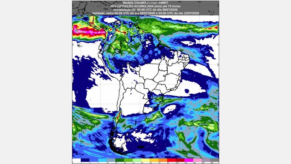
Rain will intensify again in the Southern Region between Friday (10) and Saturday (11) due to the advance of unstable areas coming from Paraguay and northern Argentina. According to the National Institute of Meteorology (Inmet), the system will also reach the south and west of Mato Grosso do Sul on Saturday, which favors the return of precipitation in these areas.
In most of Brazil, the weather will be stable due to a mass of dry air maintaining a large area of low relative humidity over the Central-West and parts of the Southeast and Northeast regions. Rainfall will remain concentrated in areas of the North region, while instabilities originating from Paraguay and northern Argentina will favor the return of rain to the South of the country. On Friday, frosts will be restricted to the mountainous regions of the Southeast.
Between Friday and Saturday, the forecast indicates rain accompanied by thunderstorms over western Amazonia, Roraima, and Rondônia, while other areas of the region may experience isolated showers. Minimum temperatures will be around 22°C in the region. Maximum temperatures will exceed 30°C throughout the region, with the highest values in southern Pará and Tocantins, where thermometers may reach 36°C. In these areas, relative humidity will remain low during the afternoons, with values below 30%, and a warning of potential danger due to low humidity during the afternoons.
Over the next two days, rain will remain confined to the coastal strip of Northeast Brazil. On Friday, rainfall will be light and isolated across much of the coast, especially between dawn and early morning. On Saturday, light and isolated showers are forecast along the coast of Rio Grande do Norte, Paraíba, and Pernambuco.
In the interior of the region, the weather remains stable, with predominantly sunny skies and little cloud cover. Under these conditions, low relative humidity continues to be a major feature of the region, encompassing southern Ceará, western Paraíba and Pernambuco, south-central Tocantins and Maranhão, and west-central Bahia, where values range between 20% and 30% during the afternoons, with a warning of potential risk due to low air humidity.
The lowest minimum temperatures in the region occur in the higher altitude areas of Bahia, with values close to 14°C. Maximum temperatures remain high in the interior of the region, reaching up to 38°C in Piauí.
On Friday, the weather will remain stable throughout the Central-West region, with no rain forecast. The predominance of dry air masses will keep the sky mostly clear. On Saturday, therefore, areas of instability originating from Paraguay will bring rain to western and southern Mato Grosso do Sul, while the remaining areas of the region will experience dry weather.
Low relative humidity prevails across much of the region, with values between 20% and 30% during the afternoons. The exception is south-central Mato Grosso do Sul, where an increase in relative humidity is expected on Saturday.
The lowest minimum temperatures occur in southern Mato Grosso do Sul, southern Goiás, and the Federal District, with values around 12°C. Maximum temperatures remain high, around 35°C in northern Mato Grosso and northern Goiás.
Between Friday and Saturday, stable weather will prevail throughout the Southeast Region, with no significant rainfall expected. However, the region will have several notable changes. The area of low humidity, for example, should decrease from Friday to Saturday, becoming restricted to the north-central and eastern parts of the state and a large part of Minas Gerais, where humidity levels will range between 20% and 30%.
On Saturday, increased cloud cover is expected in south-central São Paulo due to the advance of unstable weather systems originating from Paraguay. For the next two days, frost is also forecast in the mountainous areas located on the border between Minas Gerais and São Paulo, due to low temperatures combined with low humidity.
The lowest minimum temperatures are forecast for southern Minas Gerais and southern São Paulo, with values that could reach 4°C. In other areas of the region, minimum temperatures will be above 10°C in the coldest locations, while maximum temperatures could exceed 30°C in northern Minas Gerais, the Triângulo Mineiro region, and western São Paulo.
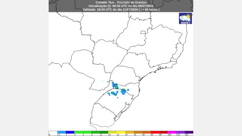
This Friday, thunderstorms will hit regions between northern Rio Grande do Sul and south-central Santa Catarina, with greater intensity on the border between the two states and in the border region with Argentina, where hail is possible. These conditions are beginning to take effect due to instabilities originating from Paraguay and northern Argentina that reach southern Brazil and favor instability in the region.
On Saturday, the weather will become more unstable, favoring rain and thunderstorms, mainly in Paraná, Santa Catarina, and the north-central region of Rio Grande do Sul. Therefore, there is a warning of potential risk for storms on both days, covering the area from northern Rio Grande do Sul to the central part of Paraná.
Regarding temperatures, minimum temperatures will rise across the region, around 10°C, while maximum temperatures will remain high in north-central Paraná on Friday, with values around 28°C. The highlight on the thermometers will be the drop in maximum temperatures on Saturday, around 20°C across the region.
Receive the latest agriculture news by email


Receive the latest agriculture news by email