




Inmet: weather forecast for Thursday (October 1st) and Friday (October 2nd)
A cold front is increasing instability in the Central-West and Southeast regions, with a risk of storms and hail.
30.09.2026 | 17:05 (UTC -3)
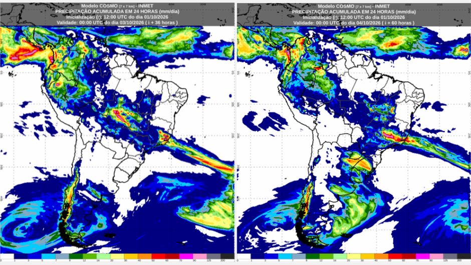
The weekend begins with conditions favorable for rain in several areas of Brazil. According to the forecast from the National Institute of Meteorology (Inmet), the passage of a cold front over the ocean favors the formation of new areas of instability, which will cause rain in the Central-West and Southeast regions and advance into parts of the Northeast, mainly over Matopiba, an agricultural region encompassing areas of Maranhão, Tocantins, Piauí, and Bahia. The instability will also advance over the North, with rain mainly in Amazonas, Acre, Rondônia, and southern Pará, as well as more isolated areas in Roraima and northwestern Pará.
In the Southern Region, Friday begins with the possibility of frost in Rio Grande do Sul and Santa Catarina, mainly in higher altitude areas. Generally, the frost should be light and isolated. On Saturday, conditions change in Rio Grande do Sul. Areas of instability advance from Argentina, causing rain and thunderstorms in the state, with an orange warning for dangerous storms. The instability may also advance to western Santa Catarina and southwestern Paraná, reaching the Foz do Iguaçu region (PR), where there is a yellow warning for potentially dangerous storms.
The change in weather conditions in the Southern Region is associated with the formation of a low-pressure area, which should move between northern Argentina and western Paraguay throughout Saturday and influence the entire Southern Region over the weekend.
Generally, temperatures will be milder than those recorded during the week in much of Brazil. Even so, the heat persists in some areas, mainly in Roraima, northeastern Pará, Amapá, and the interior of the Northeast, where temperatures may exceed 35°C during the afternoons. The weather remains more stable along the Northeast coast, although some areas may still experience isolated showers. See the forecast by region:
Friday (2/10): The week ends with sunshine and heat in Amapá and northeastern Pará. In other areas of the region, there is a chance of rain. The weather will be unstable, with showers and thunderstorms in Acre, Rondônia, Amazonas, central and southern Pará, and central, southern, and western Tocantins. In southern and western Roraima and other areas of Tocantins, isolated showers are expected. For Acre, Rondônia, Amazonas, Tocantins, southern Pará, and northwestern, western, and southern Roraima, there is a yellow warning for potential storm danger. There is also a possibility of isolated rain in northern and eastern Roraima, but sunshine will predominate and temperatures will be high. Among the capital cities, the minimum temperature will be 22°C in Rio Branco (AC), and the maximum will be 36°C in Belém (PA), Manaus (AM), and Boa Vista (RR), and 37°C in Palmas (TO).
Saturday (3/10): Rain is accompanied by thunderstorms in Amazonas, southwestern Roraima, Pará, and Tocantins. Showers are also expected in Acre, central and northern Rondônia, northwestern, central, and southern Pará, central and southern Tocantins, and other areas of Roraima. A yellow warning for potential storm danger remains in effect for western, central, and southeastern Amazonas, southwestern and southern Pará, and central and southern Tocantins. There is also a possibility of isolated rain in western Amapá, northern Tocantins, and southern Rondônia. Conversely, another sunny and hot day is expected in northeastern Pará, including Belém (PA), and in much of Amapá, including Macapá (AP). The minimum temperature will be 22°C in Rio Branco (AC). The maximum temperature will decrease slightly in Palmas (TO), after several very hot days, but will still reach 33°C. Boa Vista (RR) will be the hottest capital city, with a high of 36 °C.
Friday (2/10): The heat persists over the region, but storms are expected in Matopiba. Areas of instability forming in the interior of Brazil are reaching the interior of the region, bringing a chance of rain to southern Maranhão, southwestern Piauí, and western and southern Bahia. As a result, these areas are under a yellow warning for potential storm danger. There is also a possibility of isolated rain in Ceará, central and eastern Piauí, Rio Grande do Norte, eastern Paraíba, Pernambuco, Alagoas, and Sergipe. Despite the conditions for isolated rain, air humidity will be low during the afternoon, with a yellow warning for potential danger of low humidity in central and southern Ceará, eastern Piauí, central and northern Bahia, western Alagoas, central and western Pernambuco and Paraíba, and southwestern Rio Grande do Norte. The minimum temperature in the capitals will be 22°C in Maceió (AL), and the maximum will be 38°C in Teresina (PI).
Saturday (3/10): Instability persists in the southern part of the Northeast region. The sky will be mostly cloudy across much of the region, with isolated thunderstorms in southwestern Bahia. Showers are also expected in western and southern Bahia, and in southern Piauí and Maranhão. These areas remain under a yellow warning for potential storm danger. The minimum temperature in the capital cities will be 23°C in Recife (PE), and the maximum 38°C in Teresina (PI).
Friday (2/10): The week ends with rain in the Central-West region. In Mato Grosso, Goiás, the Federal District, and the northwest, north, and east of Mato Grosso do Sul, there will be rain with thunderstorms. Almost the entire region is under a yellow warning for potential storm danger, except for the extreme south of Mato Grosso do Sul, where conditions of greater stability prevail, with varying cloud cover. Throughout the day, the instabilities will move from the southern and western sectors of the region to the northern and eastern areas. As a result, the rain will decrease during the evening in Mato Grosso do Sul and in the central, southern, and western parts of Mato Grosso, where the sky will become mostly clear. In the northeast of Mato Grosso, the Federal District, and the north of Goiás, the instabilities will persist, with the possibility of isolated rain. Temperatures will not rise as much as during the week. The minimum temperature will be 19°C in Brasília (DF) and Campo Grande (MS). The high will be 28 °C in Campo Grande (MS) and Cuiabá (MT), and 31 °C in Goiânia (GO) and Brasília (DF).
Saturday (3/10): Unstable weather conditions persist. Rain with thunderstorms is expected in northern and eastern Mato Grosso, central and northern Goiás, and the Federal District. Isolated showers are occurring in northwestern, central, and southeastern Mato Grosso and southern Goiás. The weather will be more stable in southwestern Mato Grosso and Mato Grosso do Sul, where cloud cover will predominate. However, there is a possibility of isolated rain in eastern and northeastern Mato Grosso do Sul and the Cuiabá region. Much of the region remains under a yellow warning for potential storm danger. Only western, central, and southern Mato Grosso do Sul are outside the warning area, including the capital Campo Grande, where the day will be sunny with some clouds. The minimum temperature will be 19°C in Campo Grande (MS) and Brasília (DF), and the maximum will be 32°C in Cuiabá (MT).
Friday (2/10): In the Southeast region, the weather will be unstable this Friday. Rain with thunderstorms is expected in the Triângulo Mineiro region, northwest, north and east of São Paulo, southeast of Minas Gerais, Rio de Janeiro, and south of Espírito Santo. There is an orange warning for dangerous storms in eastern Minas Gerais and western Espírito Santo and Rio de Janeiro. For western, central and southern Minas Gerais, the Triângulo Mineiro region, and northwest, north and east of São Paulo, there is a yellow warning for potentially dangerous storms. Isolated showers are also expected in western, central and eastern Minas Gerais and Espírito Santo. Throughout the day, cloud cover should decrease in the interior of São Paulo, where the sky will be mostly cloudy. Only northeastern Minas Gerais is not expected to receive rain, remaining under a yellow warning for potentially dangerous low humidity. It will be cold in São Paulo (SP), with a minimum of 13°C and a maximum of 16°C. The temperature will drop in Rio de Janeiro (RJ), with a maximum of 25°C. In Belo Horizonte (MG), it is still hot, with a high of 30 °C.
Saturday (3/10): The weather remains unstable, with a yellow warning for potential storm danger across much of the region. Only northeastern Minas Gerais and Espírito Santo, as well as southwestern São Paulo, are outside the warning area. Rain with thunderstorms is expected in Minas Gerais, Espírito Santo, and Rio de Janeiro. Isolated showers are occurring in other areas of Minas Gerais and in northern and eastern São Paulo. In western, central, and southern coastal São Paulo, there is a possibility of isolated rain. On the border with Paraná, the sky will be mostly cloudy, but rain is not expected. Temperatures will be mild in the region. Among the capital cities, the high will be 25°C in Belo Horizonte (MG) and Vitória (ES). In Rio de Janeiro (RJ), the high will not exceed 23°C, and it will reach 21°C in São Paulo (SP).
Friday (2/10): Stable weather across much of the Southern region this Friday. The day begins with the possibility of fog in the metropolitan region of Curitiba (PR), eastern Paraná, and northeastern Santa Catarina. The day dawns cold across much of the region, with the possibility of frost in southern Rio Grande do Sul and in the central and northern regions of the state, as well as southern Santa Catarina, especially in the mountainous areas. There are more clouds over Paraná, where there is a possibility of isolated rain in the north and northeast of the state in the morning. There is also a possibility of isolated rain on the Paraná coast. In other areas, stable weather predominates, with varying cloud cover. The minimum temperature will be 9°C in Porto Alegre (RS) and 10°C in Curitiba (PR). With the cold weather in the region, the maximum temperature will not exceed 16°C in Curitiba (PR) and 17°C in Florianópolis (SC) and Porto Alegre (RS).
Saturday (3/10): The weather changes over the weekend in the Southern region, and rain returns. On Saturday, rain will hit Rio Grande do Sul, with the possibility of thunderstorms. There is an orange warning for dangerous storms. Isolated showers are also expected in other areas of Rio Grande do Sul, western Santa Catarina, and southwestern Paraná, up to the Foz do Iguaçu region (PR), where there is a yellow warning for potentially dangerous storms. In other areas, the sky will be mostly cloudy, with no rain forecast yet. The cold will lessen in the Southern region, with a minimum temperature of 10°C in Porto Alegre (RS) and Curitiba (PR), and a maximum of 23°C in Porto Alegre (RS).
Receive the latest agriculture news by email



Receive the latest agriculture news by email