



Wheat aphids challenge genetic resistance
Scientific review points to the role of insect saliva and layered defenses in the development of resistant cultivars
28.06.2026 | 15:39 (UTC -3)
The National Institute of Meteorology (Inmet) released today (June 29th) the weather forecast until July 6th. According to the institute's numerical model, the week will be marked by the passage of a cold front in the South of the country, with high rainfall accumulations, while the Central-West will have predominantly dry weather. In the North, rain continues to be frequent in parts of the region, and the cold is expected to intensify in the South and areas of the Southeast from the end of the week.
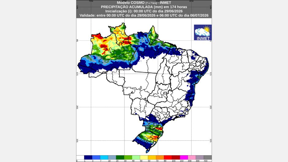
Rain remains concentrated over much of the Northern Region. The highest accumulations are expected between north-central Amazonas, Roraima, and northwestern Pará, where volumes could exceed 100 mm throughout the week. In Amapá, eastern Amazonas, and the coast of Pará, accumulations could reach 50 mm.
In Acre, southern Amazonas, and central Pará, rainfall is expected to be more irregular, with volumes around 25 mm. In Tocantins, Rondônia, and southern Pará, the forecast is for dry weather.
Temperatures remain stable in the region. The highest maximum temperatures are expected in south-central Pará, ranging between 36°C and 38°C. The lowest minimum temperatures should occur in eastern Tocantins and Acre, with temperatures close to 16°C.
The forecast indicates continued rainfall along the coastal strip between Ceará and Bahia, with light and isolated precipitation throughout the week. In Maranhão, rainfall is expected in the form of isolated showers, with accumulations that could reach 30 mm per day in the north of the state. On the northern coast of Bahia, volumes close to 30 mm are also expected in some areas, while in other areas accumulations tend to be lower.
The temperature pattern remains stable. The lowest temperatures are expected in the interior of Bahia and Pernambuco, between 16°C and 14°C at the end of the week. During the afternoons, the heat predominates, with highs of up to 36°C in northern Maranhão.
The weather remains predominantly stable in Goiás, the Federal District, north-central Mato Grosso do Sul, and south-central Mato Grosso, with no rain forecast.
However, isolated showers may occur in south-central Mato Grosso do Sul this Monday (June 29). On July 1, there is a possibility of light and isolated rain in the far north of Mato Grosso and in the south of Mato Grosso do Sul.
The lowest temperatures are expected in southern Mato Grosso do Sul, where lows could reach 12°C on Friday (July 3). In northern Mato Grosso, lows should be around 24°C, while highs could reach 36°C. In the rest of the region, maximum temperatures should range between 32°C and 34°C.
The week will be marked by predominantly stable weather, with occasional showers. In São Paulo, showers are expected this Monday (June 29th), with the possibility of isolated thunderstorms in the south of the state. Light and isolated rain returns on Friday (July 3rd).
Light rain is also forecast for the far north of Espírito Santo throughout the week and in Rio de Janeiro between July 3rd and 4th. No precipitation is expected in Minas Gerais and northern São Paulo.
The lowest temperatures are expected in the eastern part of the region, with lows between 12°C and 14°C. By the end of the week, the cold will intensify in the Serra da Mantiqueira mountain range and in southern São Paulo state, where temperatures could drop to 6°C. The highest temperatures will be concentrated in western São Paulo state, ranging between 28°C and 30°C.
The passage of a cold front will cause instability starting this Monday (June 29th), especially in Paraná, Santa Catarina, and northern Rio Grande do Sul. Rainfall totals could reach 50 mm on the day, with volumes exceeding 90 mm in parts of southern Paraná and north-central Santa Catarina.
The unstable weather conditions are expected to persist until Thursday (July 2nd), alternating between Paraná, Santa Catarina, and Rio Grande do Sul. In Rio Grande do Sul, the highest rainfall volumes are expected between July 1st and 2nd, with precipitation returning on the 5th.
Temperatures remain low throughout the region. In southern Rio Grande do Sul, minimum temperatures may fall below 4°C. Starting Friday (July 3rd), a mass of cold air will advance through the South of the country, reaching from Rio Grande do Sul to southern Paraná. In mountainous areas, the occurrence of sub-zero temperatures cannot be ruled out. The highest maximum temperatures are expected in northern Paraná, between 28°C and 30°C, while in the rest of the region temperatures should not exceed 14°C on Friday.
Receive the latest agriculture news by email


Receive the latest agriculture news by email